
Version 1.1
i
September 2022
NOAA/NESDIS/OSPO
Joint Polar Satellite System 2 (NOAA-21) Product Operations Plan (POP)
Office of Satellite and Product Operations
Joint Polar Satellite System 2 (NOAA-21)
Product Operations Plan (POP)
Version 1.1
September 2022
Prepared by:
JPSS Data Operations Manager, Office of Satellite Products and Operations (OSPO)
JPSS Product Portfolio Manager, JPSS Ground Segment DPMS
Environmental Satellite Processing Center (ESPC) System Owner, OSPO
OSPO Data Operations Support Team
U.S. Department of Commerce
National Oceanic and Atmospheric Administration
National Environmental Satellite, Data, and Information Service
Office of Satellite and Product Operations

Version 1.1
ii
September 2022
NOAA/NESDIS/OSPO
Joint Polar Satellite System 2 (NOAA-21) Product Operations Plan (POP)
Approval Page
Office of Satellite and Product Operations
Joint Polar Satellite System 2 (NOAA-21) Product Operations
Plan (POP)
GROUP: Office of Satellite and Product Operations
Jim McNitt
JPSS Data Operations Manager
GROUP: Joint Polar Satellite System Ground Segment
Lihang Zhou
Data Product Management and Services
Deputy and JPSS Product Portfolio Manager
MCNITT.JAM
ES.ALLERTO
N.1041639640
Digitally signed by
MCNITT.JAMES.ALL
ERTON.1041639640
Date: 2022.09.23
10:43:37 -04'00'
Lihang
Zhou
(affiliate)
Digitally signed by
Lihang Zhou
(affiliate)
Date: 2022.09.23
10:53:17 -04'00'

Version 1.1
iii
September 2022
NOAA/NESDIS/OSPO
Joint Polar Satellite System 2 (NOAA-21) Product Operations Plan (POP)
Changes/Revisions Record
This document is changed as required to reflect system, operational, or organizational changes.
Modifications made to this document are recorded in the Changes/Revisions Record below. This
record will be maintained throughout the life of the document.
Version
Number
Date Description of Change/Revision
Section/Pages
Affected
Changes Made by
Name/Title/
Organization
1.0
February
2022
First formal version. All
JPSS Data Operations
Manager and Data
Operations Support Team
1.1
September
2022
Changed to reflect OSPO decision to attempt to use
the NDE/PDA margin during the NOAA-21
transition, if possible.
Clarifications made to the operational declaration of
products.
Added expected dates for products to be made
available to users.
Added the steps to transition the JPSS EDRs from
operations in NDE to NCCF.
Added a list of differences in the NOAA-21 HRD
compared to the NOAA-20 HRD.
Revised the Tier (priority) definitions for S-NPP
products during the transition period to match the
priorities in the NWS Office of Observations memo
dated September 19, 2022
Added a description of the data flow during LEO&A
and after handover.
Deleted the Legacy Satellite IPT description.
Deleted assumption that described OSPO’s plans to
remove S-NPP products from ESPC Ops.
Added the steps to transition the JPSS Level 2
products from operations in NDE to NCCF.
Added details regarding the JPSS Product User
Readiness Survey.
Sections 1.1,
1.3, 1.4, 4.2, 7.1,
7.6.1, 8.1, 8.3,
8.5
JPSS Data Operations
Manager

Version 1.1
iv
September 2022
NOAA/NESDIS/OSPO
Joint Polar Satellite System 2 (NOAA-21) Product Operations Plan (POP)
Table of Contents
1. Introduction ................................................................................................................... 1
1.1. Background ....................................................................................................................................... 1
1.2. Purpose ............................................................................................................................................... 2
1.3. Scope ................................................................................................................................................... 2
1.4. Assumptions ...................................................................................................................................... 3
1.5. Constraints ......................................................................................................................................... 5
2. Referenced Documents ................................................................................................ 6
3. Overview of JPSS Product Management ................................................................ 7
4. NOAA Satellite Product Processing and Distribution Capabilities .................... 8
4.1. Current Capabilities ........................................................................................................................ 8
4.2. Planned Capabilities ...................................................................................................................... 11
5. Roles and Responsibilities ......................................................................................... 14
5.1. LEO&A R&R ................................................................................................................................. 14
5.2. Post-handover Roles and Responsibilities ................................................................................. 16
6. User Engagement ....................................................................................................... 19
7. Product Processing and Distribution during NOAA-21 LEO&A .................... 21
7.1. Timeline ............................................................................................................................................ 21
7.2. Planned Activities ........................................................................................................................... 22
7.3. Early Access Users ......................................................................................................................... 23
7.4. Product Activation Process ........................................................................................................... 23
7.5. Pre-Operational Product Generation ......................................................................................... 24
7.6. Pre-Operational Product Distribution ....................................................................................... 24
8. NOAA-21 Post-Handover Product Operations .................................................... 25
8.1. Timeline ............................................................................................................................................ 25
8.2. Planned Activities ........................................................................................................................... 27
8.3. Product Activation Process ........................................................................................................... 27
8.4. Post-Operational Product Generation ....................................................................................... 28
8.5. Post-Operational Product Distribution ...................................................................................... 29
9. S-NPP Product Availability after NOAA-21 is Declared Operational ............. 30

Version 1.1
v
September 2022
NOAA/NESDIS/OSPO
Joint Polar Satellite System 2 (NOAA-21) Product Operations Plan (POP)
9.1. Timeline ............................................................................................................................................ 30
9.2. S-NPP Product Generation and Distribution ........................................................................... 31
10. User Considerations ................................................................................................... 32
10.1. Overlap Periods .............................................................................................................................. 32
10.2. Determining User Readiness ........................................................................................................ 33
Appendix A. JPSS Data Product Maturity Stages ....................................................... 35
Appendix B. List of NOAA-21 Products ........................................................................ 36
Appendix C. NOAA-21 Product Maturity Timeline .................................................... 38
Appendix D. Assignments .................................................................................................. 39
Appendix E. NCCF Overview .......................................................................................... 41
Appendix F. End-to-End Data Flow ................................................................................ 44
Appendix G. Acronym List ............................................................................................... 45
Figure 1. Planned JPSS Constellation ............................................................................................................... 4
Figure 2. JPSS Requirements Document Hierarchy ........................................................................................ 7
Figure 3. JPSS Product Generation and Distribution Diagram ..................................................................... 10
Figure 4. JPSS and GCOM-W Product Generation in the Cloud ................................................................ 12
Figure 5. JPSS-2 KPPs Cal/Val Timeline....................................................................................................... 22
Figure 6. Product processing and distribution after Handover and prior to Operational Declaration
(L+90 days to ~L+6 months). .......................................................................................................................... 26
Figure 7. Product processing and distribution after Operational Declaration and prior to NOAA-21
being made primary (~L+6 months to about L+9-12 months).. ................................................................... 26
Figure 8. List of JPSS Products.. ..................................................................................................................... 36
Figure 9. NOAA-21 Product Maturity Timeline. .......................................................................................... 38
Figure 10. NCCF and FISMA Boundaries ..................................................................................................... 42
Figure 11. NCCF Roadmap ............................................................................................................................. 43
Table 1: JPSS-2 Products Planned Provisional Maturity Level Review Dates and SPSRB Date ............. 30
Table 2. NOAA-21 Product List ..................................................................................................................... 37
Table 3. Assignments ...................................................................................................................................... 40

Version 1.1
1
September 2022
NOAA/NESDIS/OSPO
Joint Polar Satellite System 2 (NOAA-21) Product Operations Plan (POP)
1. Introduction
1.1. Background
Within NOAA’s National Environmental Satellite, Data, and Information Service (NESDIS), the Joint
Polar Satellite System (JPSS) Program and Office of Satellite and Product Operations (OSPO) work
together to transition new JPSS series satellites to operations.
OSPO’s Environmental Satellite Processing Center (ESPC) serves as the near real-time data center that
ingests, processes and distributes environmental satellite data products and information from NOAA
and non-NOAA managed satellites. OSPO’s ESPC serves as the civilian interface for data access for
both government agencies and international partners. Additionally, ESPC distributes near real-time
data to authorized academic institutions and commercial enterprises. The ESPC systems for product
generation and product distribution are the NOAA Data Exploitation (NDE) and Product Distribution
and Access (PDA). OSPO’s JPSS product generation capability is migrating from NDE to the
NESDIS Common Cloud Framework (NCCF). The NOAA-21 products will be generated on NCCF
and distributed to users through the ESPC’s PDA.
The JPSS series of satellites consists of Suomi National Polar-orbiting Partnership (S-NPP), NOAA-
20, JPSS-2, JPSS-3, and JPSS-4.
1
The JPSS satellites provide critical environmental data collection
required by the nation to monitor real-time weather events and for inclusion into numerical weather
prediction to improve accuracy and reduce uncertainty in medium range forecasts. The fly-out charts
are available at: https://www.nesdis.noaa.gov/current-satellite-missions/currently-flying
JPSS-2 will be renamed NOAA-21 after the satellite reaches orbit. Preparations for NOAA-21 data
product operations include the test activities described in the JPSS-2 Product Test Plan (PTP). the
NOAA Center for Satellite Applications and Research (STAR) activities to prepare for the NOAA-21
calibration and validation (Cal/Val). NOAA STAR has delivered updated JPSS-2 product algorithms
to JPSS Ground Segment’s Data Product Management and Services (DPMS) for implementation in
the Interface Data Processing Segment (IDPS). IDPS generates the Mission Unique Products and
distributes the products to the ESPC, Cal/Val teams, and NOAA’s archive. Initially, OSPO will
generate and distribute NOAA-21 products to operational users through the ESPC’s on-premise
systems (NDE and PDA). NESDIS is planning to transition OSPO’s JPSS product generation
capabilities to NCCF.
Recent regression testing using a peak loading profile on ESPC I&T indicates that the existing ESPC
system (NDE/PDA) margin could potentially support up to three JPSS satellites for a limited time to
support the NOAA-21 transition. This would exceed the requirements, but the safety margins can be
adequately maintained. Caveats include:
● ESPC OPS environment has a different load profile (more missions and users)
● Mitigation: If ESPC OPS safety margin is exceeded, or if staff resources are not available, then
OSPO will withdraw back to the two [2] JPSS satellite processing/distribution requirement
If possible, groups of S-NPP products will remain on NDE/PDA OPS until the equivalent NOAA-21
products reach Provisional, to help ensure continuity.
1
https://www.jpss.noaa.gov/mission_and_instruments.html

Version 1.1
2
September 2022
NOAA/NESDIS/OSPO
Joint Polar Satellite System 2 (NOAA-21) Product Operations Plan (POP)
1.2. Purpose
The purpose of this document is to describe the work required to process and distribute NOAA-21 data
products during Launch, Early Orbit & Activation (LEO&A) and after handover to OSPO for nominal
operations. The plan provides the timeline and roles and responsibilities for transitioning NOAA-21
products to the ESPC operations environment, including Cal/Val. The document will help users set
expectations regarding access to NOAA-21 products.
1.3. Scope
The scope of the JPSS-2 POP includes the JPSS data product workflow and the systems that support
the workflow. The JPSS workflow described in this plan is the sequence of processes that generate and
distribute JPSS products. This document describes the management of the JPSS product distribution
by OSPO ESPC during LEO&A and after handover until NOAA-21 is designated the primary JPSS
satellite, and all NOAA-21 products reach at least the Provisional maturity level.
2
The product
maturity stages are listed in Appendix A.
The primary goal during this period will be to process and distribute the following:
● NOAA-21 Key Performance Parameter (KPP)
3
products to the National Weather Service for its
National Centers for Environmental Prediction (NCEP) and Alaska Region.
● Available NOAA-21 data products to the NOAA STAR Cal/Val teams.
● Beta-level NOAA-21 products to authorized users.
● Provisional-level NOAA-21 products to operational users.
The secondary goal will be to distribute the following:
● S-NPP and NOAA-20 KPP products to NCEP and other Numerical Weather Prediction (NWP)
centers to support the evaluation of NOAA-21 KPP products, calculate bias errors, and tune the
data assimilation and forecast modeling systems.
● S-NPP and NOAA-20 products to STAR to support the NOAA-21 Cal/Val activities as
described in the Cal/Val plans. The Cal/Val plans are located at:
https://www.star.nesdis.noaa.gov/jpss/Docs.php
Minimum system success of the JPSS requires all four performance attributes identified as KPPs listed
below to be met for one set of products. KPPs are those polar system capabilities that, if they cannot be
met, would compromise NOAA’s weather mission to provide essential warnings and forecasts to
protect lives and property. Per the JPSS Level 1 Requirements Document (L1RDS)
4
, the JPSS KPPs
are:
● Advanced Technology Microwave Sounder (ATMS) Temperature Data Records (TDRs)
● Cross-track Infrared Sounder (CrIS) SDRs
2
Primary Satellite: For polar-orbiting operational satellites, the primary satellite designation indicates that the satellite and
KPP sensors have been capitalized by NOAA, the KPP products have been validated to a level of maturity which allows their
operational use, users are ready to use KPP products operationally, and all IT systems required to acquire, process and
distribute KPP products have an Authorization to Operate.
3
KPPs are defined in the JPSS Level 1 Requirements (L1RDS) - J2 Follow-On Final
4
https://www.jpss.noaa.gov/assets/pdfs/technical_documents/L1RD.pdf

Version 1.1
3
September 2022
NOAA/NESDIS/OSPO
Joint Polar Satellite System 2 (NOAA-21) Product Operations Plan (POP)
● For latitudes greater than 60ºN in the NWS Alaska Region, Visible Infrared Imaging
Radiometer Suite (VIIRS) Imagery Environmental Data Record (EDR) at 0.64μm (I1), 1.61μm
(I3), 3.74μm (I4), 11.45μm (I5), 8.55 μm (M14), 10.763 μm (M15), 12.03 μm (M16), and 0.7
μm Near Constant Contrast (NCC) EDR.
● 87-minute data latency for the ATMS TDRs, CrIS SDRs and the VIIRS Imagery EDR channels
specified above.
During the LEO&A period the emphasis will be on getting the NOAA-21 KPP products to Provisional
maturity. After data starts flowing from a NOAA-21 instrument, then IDPS Ops will generate RDR,
SDR, and TDRs and distribute products to NDE, Government Resource for Algorithm Verification,
Independent Test, and Evaluation (GRAVITE), and Comprehensive Large Array-data Stewardship
System (CLASS) as restricted data. NDE will process the data on NDE I&T until the products reach
the Provisional maturity level and are approved for operations through the Satellite Products and
Services Review Board (SPSRB) process. At that point ESPC will process the data on NDE OPS and
distribute the products through PDA OPS. During the post-handover period, the emphasis will be to
process and distribute in near-real time, products in ESPC Ops that have reached provisional maturity
and have been declared operational.
1.4. Assumptions
1.4.1. JPSS-2 Product Test Plan (PTP) objectives met prior to launch
The JPSS-2 Product Test Plan (PTP) objectives include:
● KPP products are operational by L+90 days (same as NOAA-20).
● All "JPSS-2-ready" EDR algorithms should be integrated into the NDE I&T string in time for
the various test events outlined in this test plan
● All IDPS sensor and temperature data records from OMPS and VIIRS (not covered in
Objective 1) transition to operations faster than NOAA-20
The PTP also lists the Cal/Val group objectives deemed necessary to verify the functionality of all
science data products pre-launch and describes how to best meet those objectives pre-launch test
objectives. The Cal/Val objectives are:
● Deliver all JPSS-2 (NOAA-21) specific SDR, TDR, and EDR algorithms, including any
changes needed to meet geolocation requirements, nine months prior to JCT 3 for
incorporation into their respective ground processing systems
● Participate in a minimum two end-to-end (E2E) JPSS-2 test data flows (including JCTs) from
the satellite down to all Cal/Val Group members to verify functionality of the system and
algorithms prior to launch
● Support STAR Science Team requests for specific specialized data sets via the JPSS-2 Test
Data and Tools Working Group (TD&TWG) test data request process
For planning purposes, we assume those Cal/Val objectives will be met prior to the NOAA-21 launch.
1.4.2. JPSS Constellation Orbit
The current plan is to place NOAA-21 a quarter orbit ahead of S-NPP and a quarter orbit behind
NOAA-20. The three observatories will stay in this configuration with NOAA-20 leading until
NOAA-21 is declared primary for the 1330 LTAN. After NOAA-21 is designated primary, the

Version 1.1
4
September 2022
NOAA/NESDIS/OSPO
Joint Polar Satellite System 2 (NOAA-21) Product Operations Plan (POP)
operations team will move NOAA-20 forward to give NOAA-21 and NOAA-20 the required half
orbit separation.
Figure 1. Planned JPSS Constellation
Joint Polar Satellite System (JPSS-2/3/4) Satellite Handover and Transition Plan (472-00858) details
the process for the JPSS Program to hand-over and transition NOAA-21 to OSPO. The NOAA-21
Post-Launch Assessment Review (PLAR) will be held when the PLAR entrance criteria are met.
During the PLAR the JPSS Flight Project will demonstrate that NOAA-21 is in compliance with the
mission design/performance requirements; confirm that all verification and on-orbit commissioning
and Post Launch Testing (PLT) activities are completed; and review and close any waivers or
deviations. OSPO will confirm readiness to support long-term operations.
The earliest the PLAR could be held is at launch plus 3 months. After a successful PLAR and when
OSPO assumes the responsibility for NOAA-21 mission operations. At that point, the satellites
assignments will be:
● Primary: NOAA-20
● Secondary: S-NPP
● Tertiary: NOAA-21
When the NWS confirms that the NWS NCEP Central Operations (NCO) is ready to assimilate the
NOAA-21 data in the modeling system and the performance of the VIIRS Imagery product is
acceptable, then NOAA-21 will be declared operational and the satellites assignments will be:
● Primary: NOAA-20
● Secondary: NOAA-21
● Tertiary: S-NPP
When the criteria are met to designate NOAA-21 the primary satellite (the target timeframe is launch
plus 9 to 12 months or later) then the satellites assignments will be:
● Primary: NOAA-21
● Secondary: NOAA-20
● Tertiary: S-NPP
The primary designation could be delayed. The JPSS data latency requirement is documented in the
Level 1 Requirements (L1RD) and JPSS ESPC Requirements Document (JERD). Data Latency is
defined as the period from the time of observation of all requisite data by the satellite until the EDR or
data product produced from those data is available to the user at the distribution system. L1RD-154
states the following:

Version 1.1
5
September 2022
NOAA/NESDIS/OSPO
Joint Polar Satellite System 2 (NOAA-21) Product Operations Plan (POP)
“On a 30-day basis, data latency requirements, as specified in Appendix A, Table 1 and Table 1.1,
shall be met at least 95% of the time for data collected by the primary operational sensors on the JPSS
[Priority 1] and GCOM [Priority 3] satellites. Mission Effectivity: JPSS-1, JPSS-2, JPSS-3, JPSS-4.”
The NCCF data latency will not be measured until NCCF is near full capacity (i.e., all planned
enterprise algorithms running in NCCF). Since OSPO is required to meet L1RDS-154 with the
primary satellite, the NOAA-21 designation could be delayed until the end-to-end latency is measured.
1.4.3. JPSS Level 2 product generation migrating to the Cloud
Currently, NESDIS is planning to transition OSPO’s JPSS and Global Change Observation Mission
1st - Water (GCOM-W) product generation capabilities to NCCF, in coordination with the ongoing
Legacy Migration. The JPSS Ground Segment has implemented an initial IDPS interface with NCCF.
The Office of Satellite Ground Services (OSGS), STAR, and DPMS, coordinated schedules to agree
on NCCF Operational Readiness Review (ORR) dates for the NOAA-21 products. OSGS will deliver
a Minimally Viable Product (MVP) to ingest and generate S-NPP, NOAA-20, and GCOM-W Level 2
products in the NCCF during CY2022. The NCCF is described in Appendix E. The initial IDPS to
NCCF interface is not a fully operational interface. This initial interface was built to distribute IDPS
data to NCCF during product integration.
1.4.4. JPSS product distribution migrating to the Cloud after FY2025
OSPO’s JPSS product distribution capability will start migrating to the Cloud in FY2023 and the
migration is expected to be completed in FY2025. For the purpose of the plan, the on-premise PDA
will remain the primary access node for operational users who require near-real-time JPSS data
products until after NOAA-21 is designated the primary satellite.
1.4.5. S-NPP becomes tertiary when NOAA-21 is declared operational and NWS is
assimilating NOAA-21 data
OSPO plans to continue to operate the S-NPP satellite after the NOAA-21 satellite is declared
operational. OSPO plans to operate the S-NPP satellite at least until NOAA-21 is designated the
primary satellite, as no formal guidance to decommission S-NPP has been provided. Note that S-NPP
was designed to support controlled reentry at the end of its mission life. OSPO can command
propulsive maneuvers to lower the orbit perigee to approximately 50 km and target any surviving
debris for open ocean entry. Due to resource constraints at OSPO the S-NPP spacecraft will be
operated at a lower priority than the primary and secondary satellites. The S-NPP VIIRS Lunar Roll
for VIIRS calibration activities will need to be scheduled in such a way that it does not interfere with
the primary and secondary satellite operations.
1.4.6. IDPS will continue to process S-NPP Level 1b products
IDPS will continue to generate S-NPP RDRs, SDRs, and TDRs and will distribute the products to
ESPC, GRAVITE for distribution to the STAR Central Data Repository (SCDR), and to CLASS, for
archive.
1.5. Constraints
1.5.1. NDE, PDA, and CLASS capacity designed, sized, and built for two JPSS
satellites
OSPO's ESPC capacity was designed and built for two JPSS satellites. The ESPC systems (NDE and

Version 1.1
6
September 2022
NOAA/NESDIS/OSPO
Joint Polar Satellite System 2 (NOAA-21) Product Operations Plan (POP)
PDA) inherited the two-JPSS satellite requirement from the JPSS Program and are sized for a capacity
of two JPSS satellites. CLASS was also designed and built for two JPSS satellites.
Based on the ESPC I&T data loading, OSPO has determined that NDE/PDA/CLASS should be able
to handle the load during the transition of NOAA-21 products through full validation. However, OSPO
will reassess the data loading on ESPC OPS after the JPSS-2 launch with NOAA-21 products flowing.
No commitment will be made until after JPSS-2 launch and after data loading is reassessed. Even if
selected S-NPP products remain on ESPC Ops, if OSPO determines that the safety margin is
exceeded, then OSPO will incrementally withdraw back to the two JPSS satellite
processing/distribution requirements.
CLASS will archive on-premises and in AWS any Operational data received. The larger CLASS user
community will have access to any data that is archived.
2. Referenced Documents
a. JPSS Level 1 Requirements - J2 Follow-On Final L1RDS
b. JPSS Ground System Concept of Operations, Rev G
c. Joint Polar Satellite System – 2 (JPSS-2) Product Test Plan (PTP), 474-01598, Revision - Joint
Polar Satellite System (JPSS) Code 474
d. Joint Polar Satellite System (JPSS) Environmental Satellite Processing Center (ESPC)
Requirements Document (JERD), Volume 1
e. Environmental Satellite Processing and Distribution System (ESPDS) Development Enterprise
System Requirements Document (ESRD), Version 2.3
f. JPSS Ground Segment Data Product Specification, 474-01543, Revision G
g. JPSS Common Data Format Control Book – External, Volume I - Overview
h. NESDIS Memo: Transition to NESDIS Common Cloud Framework (NCCF), April 2021
i. The Suomi National Polar Orbiting Partnership (S-NPP) Data Exploitation (NDE)
j. Algorithm Change Management Process (ACMP) Handbook, Version 1.0, September 2020
k. JPSS Algorithm Change Management Plan
l. JPSS-2 Flight Transition Plan (Draft)
m. Cloud Computing Lexicon and Related Terms
n. NESDIS Level Requirements, NESDIS-REQ-1001.1 (2020)
o. The NDE – NCCF Products Transition to Operations Process document, Version 1.0, March
2022
p. NOAA NWS Office of Observations Memo to OSPO Director and JPSS Program Director
dated September 19, 2022, NWS Feedback on Extended S-NPP Product Support on ESPC/OPS
Beyond S-NPP/JPSS-2 Transition

Version 1.1
7
September 2022
NOAA/NESDIS/OSPO
Joint Polar Satellite System 2 (NOAA-21) Product Operations Plan (POP)
Figure 2. JPSS Requirements Document Hierarchy
3. Overview of JPSS Product Management
The SPSRB is responsible for the oversight and guidance necessary to effectively manage the product
life cycle process from product development, transition into operations, enhancements and retirement.
The SPSRB process relies upon appointed individuals to execute the functions of SPSRB positions,
working groups, or advisory boards. The NESDIS STAR, OSPO, and Office of Satellite Ground
Services (OSGS) Office representatives comprise the voting members. Interested observers include
National Centers for Environmental Information (NCEI), NWS, National Ocean Service (NOS),
National Marine Fisheries Service (NMFS), Oceanic and Atmospheric Research (OAR), OSAAP,
JPSS, GOES-R, and program scientists. The SPSRB Executive Board meets as needed to review and
approve new processes and policies. The board also provides guidance on how to address outstanding
SPSRB issues. The SPSRB provides a forum for NESDIS offices and stakeholders to monitor the
progress of product development, approve new products going into operations, and approve
retirements and divestitures of operational requirements. The SPSRB membership is composed of
representatives from NESDIS offices and user organizations. The SPSRB also provides satellite
product development guidance and policy.
NESDIS is currently going through a number of changes related to Product Portfolio Management.

Version 1.1
8
September 2022
NOAA/NESDIS/OSPO
Joint Polar Satellite System 2 (NOAA-21) Product Operations Plan (POP)
NESDIS is planning and funding science product Transition to Operations (T2O) projects with an
emphasis on continuity and sustainment of products and algorithms. In May 2020, the NESDIS
Executive Council approved the establishment of the Product Portfolio Management (PPM) team to
lead the FY21 Data Agnostic Common Services (DACS) Management Demonstration.
The PPM team oversees management of the algorithm portfolios from formulation through retirement.
The PPM team manages the NOAA L2+ products (e.g. EDRs), but not the RDRs and SDRs. The
PPM Team also manages the non-NOAA products. The PPM is responsible for oversight of
development and implementation of science algorithm projects in order to maintain product quality
and performance while leveraging continuous science improvement. The PPM Team will ensure
effective integration of data from applicable data sources and retirement of old sources.
The SPSRB processes are evolving to keep pace with these ongoing changes within NESDIS. At some
point the SPSRB approval review meeting will be replaced by a combined Algorithm Readiness
Review (ARR)/Operational Readiness Review (ORR) for Level 2 products.
4. NOAA Satellite Product Processing and Distribution Capabilities
4.1. Current Capabilities
4.1.1. Satellite Downlink and Stored Mission Data Handling
Once per orbit, the S-NPP Stored Mission Data (SMD) is downlinked through a 300 Mbps X-band
link and acquired by a JPSS X-band antenna at Svalbard. The SMD is preprocessed into annotated
Virtual Channel Data Units (aVCDU) and routed to the JPSS SMD Hub (JSH) in CONUS. The JSH
relays the aVCDUs to the NASA Science Data Segment (SDS) in near real-time. It also extracts S-
NPP Application Packets (APs) and forwards them to the JPSS Data Processing Nodes, where it is
fully processed into S-NPP data products (xDRs) for delivery and archive. The S-NPP APs are also
made available to Fleet Numerical Meteorology and Oceanography Center (FNMOC).
5
In addition to
the primary SMD receiving site at Svalbard, S-NPP also uses OSPO’s Fairbanks Command and Data
Acquisition Station (FCDAS) as an additional site for the SMD operations.
Unlike S-NPP, NOAA-20 uses the JPSS Ka-band receptors at Svalbard, Fairbanks, McMurdo Station,
and Troll for its mission data acquisition. The Troll Satellite Station (TrollSat) operated by Kongsberg
Satellite Services (KSAT) is located at Jutulsessen, Antarctica. These four locations for receptors
provide opportunities for two SMD contacts during each orbit, significantly reducing data latency to
less than 80 minutes compared to less than 140 minutes for S-NPP. During each contact, the SMD is
down-linked via a 300 Mbps Ka-band link and acquired by a JPSS Ka-band receptor.
The SMD is preprocessed into aVCDUs and routed to JSH in CONUS. The JSH relays the VCDUs to
the NASA SDS in near real-time. It also distributes aVCDUs to FNMOC. FNMOC uses the
Community Satellite Processing Package (CSPP) software to generate xDRs. JSH extracts the APs and
forwards them to the IDPS in the Cloud, where the data are fully processed into JPSS data products
(xDRs) for delivery to the ESPC, GRAVITE, and CLASS.
In addition to using the SMD receiving sites at Svalbard, Fairbanks, Troll, and McMurdo, NOAA-20
5
The JSH provided data to the Naval Oceanographic Office (NAVOCEANO) until 2020. NAVOCEANO discontinued its
use of JSH in Spring 2020.

Version 1.1
9
September 2022
NOAA/NESDIS/OSPO
Joint Polar Satellite System 2 (NOAA-21) Product Operations Plan (POP)
also utilizes the Tracking and Data Relay Satellite System (TDRS) as a contingency for transmitting
SMD to the JPSS Ground System. Utilizing TDRS during anomalies for data acquisition maintains
data product latency performance in case of polar ground station or satellite nadir Ka antenna failure.
4.1.2. Interface Data Processing Segment (IDPS)
IDPS ingests the JPSS Stored Mission Data (SMD) from the Command, Control and.
Communications Segment (C3S) and then generates RDRs, SDRs, and TDRs. The artifacts from
satellite on-board storage and ground communication routing are removed prior to arrival at the IDPS,
with initial ingest processing providing RDRs (per sensor/channel raw bits). The RDRs are processed
with the appropriate Mission Support Data (MSD) in the IDPS to produce SDRs (geolocated and
calibrated samples), TDRs, IPs, and the VIIRS Imagery EDR. The JPSS RDRs, SDRs, IPs, TDRs,
VIIRS Imagery EDRs, and associated metadata are then distributed to configured recipients such as
ESPC, GRAVITE, CLASS, and NASA SDS. The recipients have the option of receiving products
compressed or uncompressed (RDRs are never compressed). IDPS can generate and distribute Mission
Unique Products (MUP) for three JPSS satellites.
IDPS transitioned to the Cloud in 2021.The initial migration of the IDPS on-premise operational
baseline to the Cloud was completed with minimal baseline changes in order to avoid hardware
obsolescence issues. The only changes made to the baseline were the changes designated as explicitly
necessary to operate in the Cloud.
4.1.3. Environmental Satellite Processing Center (ESPC) Systems
The ESPC is NOAA's primary data-processing system for the Nation's environmental satellite data and
it is located at the NOAA Satellite Operations Facility (NSOF) in Suitland, MD. Through a large
variety of hardware, software, networks, telecommunication lines, and software tools; ESPC ingests,
processes, and distributes environmental data and information received from all of NOAA's satellites,
several foreign countries' satellites and the Department of Defense's (DoD) satellites. ESPC includes
the operational satellite data distribution network which provides NESDIS' customers access to real-
time or near real-time environmental data and information on a continuous (24 hours per day/7 days
per week) basis. The primary product applications are near real-time imagery, interactive products, and
automated products, used by NWS and DoD as inputs to analyses and forecast models.
The ESPC systems used for JPSS data processing were developed by the Office of Satellite Ground
Services (OSGS) as the Environmental Satellite Processing and Distribution Services (ESPDS). The
major ESPDS segments are ingest, product generation, product distribution, and infrastructure. The
Product Generation (PG) Segment is NDE. The Product Distribution (PD) Segment is PDA. The PDA
distributes products to authorized, operational real-time users through terrestrial networks and point-to-
point connections. The ESPC infrastructure consists of storage devices, enterprise services, security
devices, and networks. A high reliability infrastructure is critical to maintain NOAA satellite ingest,
data processing and distribution on an uninterrupted 24x7 basis.
Version 1.1
10
September 2022
NOAA/NESDIS/OSPO
Joint Polar Satellite System 2 (NOAA-21) Product Operations Plan (POP)
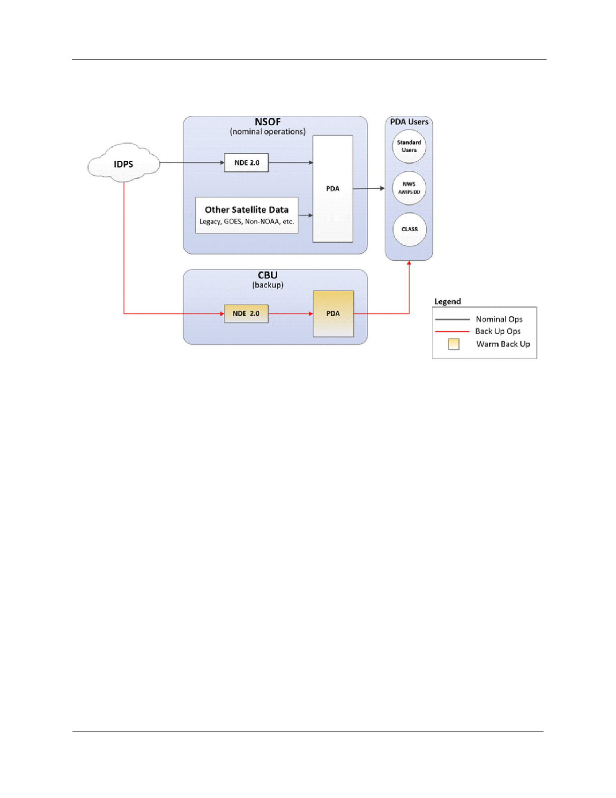
Figure 3. JPSS Product Generation and Distribution Diagram
4.1.3.1. NOAA Data Exploitation (NDE)
The NDE system has three environments; Operational (OPS), System Test (TEST), and Development
(DEV), and the Consolidated Backup (CBU). Each environment provides the following JPSS
capabilities:
● Receives RDRs, SDRs, and TDRs from IDPS.
● Generates EDRs.
The NDE provides the following JPSS product generation and distribution capabilities:
● Receives and processes Level 1b products (RDRs, SDRs, and TDRs (ATMS) from S-NPP,
GCOM-W1, NOAA-20, and JPSS-2/3/4 that are generated on IDPS
● Generates tailored and Binary Universal Form for the Representation of meteorological data
(BUFR) formatted files.
● Forwards products to the PDA for distribution to customers.
NOAA STAR developed a tailoring software system that converts satellite operational products into
BUFR formatted files. The Reformatting Toolkit converts the products from the JPSS CrIS and ATMS
and GCOM-W1 Advanced Microwave Scanning Radiometer 2 (AMSR2). The toolkit is running in
the NDE.
The ESPDS Product Generation (PG) Integrated Product Team (IPT) and the Product Readiness TIM
(PRT) together are the change control process that ensures the NDE system continues to maintain its
standard of data. New or updated NESDIS NOAA Unique Products (NUPs) are delivered to NDE in

Version 1.1
11
September 2022
NOAA/NESDIS/OSPO
Joint Polar Satellite System 2 (NOAA-21) Product Operations Plan (POP)
the form of Delivered Algorithm Packages (DAPs). DAPs contain all the necessary information,
including Look-up Tables (LUTs) and source code required for implementing updates to Science
Algorithms (SAs) in the NDE Data Handling System (DHS).
The DAP delivery process and Science Algorithm (SA) integration into NDE are facilitated by the
product Integrated Product Team (pIPT), which is composed of Product Area Leads (PALs) from
OSPO and NDE Algorithm Integrators (NALI), as well as algorithm developers and testers from
STAR.
4.1.3.2. Product Distribution and Access (PDA)
The PDA is responsible for implementing the processes and providing the services needed to access
and distribute NESDIS data from multiple sources to the near real-time user community in support of
the NESDIS mission to provide timely access to global environmental data from satellites and other
sources to promote, protect, and enhance the Nation’s economy, security, environment and quality of
life. Primary users of this system include the NWS NCEP NCO, NWS AWIPS Network Control
Facility (NCF), NMFS, NOS, NESDIS, the U.S. National Ice Center (USNIC) and various elements of
the DoD. Additionally, the system will support long-term data archival by providing select data to the
CLASS. The system consists of a data receive point, a user access point and temporary data store. The
user access point is a user interface, consisting of both a Graphical User Interface (GUI) and an
Application Programming Interface (API), whereby users are able to search for data, establish data
subscriptions and make ad-hoc data requests. PDA gets the data from the Data Providers either through
data “Push” or data “Pull.” The PD Segment provides a unique directory structure for each data file
that is inventoried within the PD Segment through these interfaces. The directory structure design
supports unique identification of each Data File that is critical to fulfill the ESPDS business functions,
such as data search, and data request. Metadata describes a data file in inventory. The PD Segment
uses metadata to inventory the data and make it available to Data Consumers for access to the data
through search leading to an ad hoc request of the data file. PDA currently distributes S-NPP and
NOAA-20 data records and information received from the JPSS Common Ground System (CGS) to
the NOAA user community.
4.2. Planned Capabilities
In accordance with NESDIS Cloud guidance, OSGS is transitioning OSPO’s current PG capabilities
from the ESPC NDE to the NCCF PG Service. OSGS plans to exploit NCCF services and leverage
NCCF’s inherent scalability.
The migration of JPSS and GCOM-W PG capabilities will be accomplished incrementally using SAFe
and DevOps methodologies. The approach is to deliver a Minimally Viable Product (MVP) to ingest
and generate JPSS and GCOM-W products in the NCCF during CY 2022. This will ingest JPSS &
GCOM-W data from IDPS, integrate Enterprise Cloud Containerized Algorithm Packages (CCAP),
generate associated products, and distribute to NODD and on-premise PDA. CLASS can provide a
Cloud-based interface with data providers in addition to on-premises. Archive will be on-premise
CLASS until NCCF archive capabilities have been implemented. The MVP capability is a proof of
concept capability that will provide products in a minimally useful form. The value will be to

Version 1.1
12
September 2022
NOAA/NESDIS/OSPO
Joint Polar Satellite System 2 (NOAA-21) Product Operations Plan (POP)
demonstrate JPSS and GCOM-W Product Generation in NCCF.
Figure 4. JPSS and GCOM-W Product Generation in the Cloud
There are several teams involved: the JPSS STAR science teams, OSGS Algorithm Scientific
Software Integration and System Transition Team (ASSISTT), OSGS PG Migration to NCCF project,
JPSS Ground Segment's DPMS for product maturity reviews, SPSRB (evolving to an ARR/ORR),
and ESPC Team (for product distribution through Product Distribution and Access (PDA) OPS).
Following the MVP proof of concept demonstration, OSGS will incrementally expand NCCF
capability to include the full complement of needed NDE algorithms and products. NESDIS’ goal is
to migrate NDE capabilities to NCCF so that the on-premise NDE instance at NSOF and CBU can be
decommissioned.
The NDE – NCCF Products Transition to Operations Process document describes the steps to
transition the JPSS KPPs and EDRs from operations in NDE to NCCF.
The steps:
1. JSTAR delivers to ASSISTT.
2. ASSISTT delivers the CCAP.
3. The NDE to NCCF Dev/Ops team will integrate the CCAP in the development environment
(DEV) and generate the products from the same (or upgraded) algorithms as on-prem NDE.
4. ASSISTT verifies implementation of algorithms in the DEV environment.
5. STAR, OSGS and OSPO PALS will validate the products generated from NCCF in UAT
(NCCF Integration environment in 5045) and ensure that any deltas are near zero or are
explainable.

Version 1.1
13
September 2022
NOAA/NESDIS/OSPO
Joint Polar Satellite System 2 (NOAA-21) Product Operations Plan (POP)
6. JPSS PAL will notify the existing I&T users from NCEP, EUMETSAT, and DoD of transition
of NCCF product to PDA I&T - this serves to notify users that the product is transitioning to
operational NCCF.
7. The operational quality products (Beta maturity level) will flow from NCCF UAT to PDA I&T
and will remain there for a proposed 30 day-long time-frame. This will allow key users to
confirm user readiness and product consistency. In PDA I&T, we will use the same parallel
production with NDE distribution to PDA turned off as described below unless preempted by
urgent work such as an Emergency Directive issued by DHS/CISA or another equivalent urgent
action being required.
8. The product filenames (regex) will remain the same, but the version number will restart from the
on-prem version or higher.
9. JPSS Program Science/DPMS will hold the Provisional product maturity review. Note that
STAR will conduct the Cal/Val using EDRs generated at STAR (not on NCCF).
10. Product monitoring (quality and visualization) tools for the transitioned NDE products,
monitoring of incoming data and products sent to PDA should be in place prior to the transition
date to operations.
11. Conduct the Product ORR.
12. SPSRB approval to transition into NCCF OPS.
13. On a determined date, the NCCF product will become operational and the product generated in
on-prem NDE will be retired. This shall be after the parallel operations period in I&T as
described in #6 above. The JPSS Data Operations Manager will coordinate the cutover decision
through the Polar Product Operations and Readiness Team (PORT).
14. OSPO User Services will issue an ESPC notification with PALs and NDE & PDA lead input
detailing the date and time of the product transition. The notification process will follow the
guidance and standards of the NESDIS OSPO Operational Data Products Change Notification
Policy (NESDIS-PD-7102.1).
15. The products will continue running in parallel on the on-prem NDE, for a period of time,
currently proposed for no longer than 30 days. This provides the flexibility to have the products
on the NDE but not on PDA, as a fall back. There is a flag called "distribute to PDA" in the
NDE product definitions for all NDE products. This flag can be turned off to keep on-prem
NDE generating all products or any subset products but not sending to PDA. Subscription
remains the same.
16. At the end of the proposed time period, the on-prem NDE team will disable Product Generation
in NDE on-prem as products are turned on from NCCF. At this time, ensure that the on-prem
NDE products using the NCCF upstream products as inputs work in NDE I&T. Will need to
turn off production rules in NDE in exchange for PDA rule.

Version 1.1
14
September 2022
NOAA/NESDIS/OSPO
Joint Polar Satellite System 2 (NOAA-21) Product Operations Plan (POP)
Although NESDIS also plans to migrate the PD capabilities to the Cloud, the on-premise PDA is
expected to serve as ESPC’s primary PD node at least through FY2025. The exception is NOAA
STAR, which plans to retrieve products from NCCF early.
5. Roles and Responsibilities
5.1. LEO&A R&R
5.1.1. OSPO JPSS Data Operations Manager
The JPSS Data Operations Manager (DOM) works in OSPO’s SPSD. The JPSS DOM will:
● Provide oversight for this plan.
● Monitor progress.
● Recommend controls to improve schedule performance.
● Coordinate with the PPM, DPMS, JPSS PAL, ESPC System Owner, JPSS Product Engineer,
NDE System Lead, and PDA Manager.
● Cochair the Polar Product Operations and Readiness Team (Polar PORT).
● Lead the Data Operations Support Team (DOST).
5.1.2. OSPO Mission Operations Division (MOD) Systems Branch
The MOD System Branch is responsible for NDE and PDA operations and maintenance.
● The Branch’s NDE System Lead will:
o Work with the PALs to verify that DAPs and production rules for NOAA-21 are in place.
Control the subscriptions. Determine what data flows to PDA I&T and OPS.
● The Branch’s PDA Manager will:
o Ensure catalog entries are created on PDA for NOAA-21 products.
o Make pre-operational data available to approved users. Assist users with subscriptions on
PDA as needed.
5.1.3. Office of Satellite Ground Services (OSGS)
● The ESPDS Sustainment team will implement the DAPs and production rules for NOAA-21.
5.1.4. OSPO SPSD Satellite Products Branch (SPB)
The Branch’s JPSS PAL will work with the other PALs in the Branch to:
● Ensure KPP data products meet the requirements as stated in the JPSS Ground Segment Data
Product Specification.
● Prepare SPSRB operations briefings.
● Transition products to operations once approved by SPSRB.
● Verify with the NWS NCEP that the BUFR products can be decoded properly.
5.1.5. JPSS Program Scientist
● Chairs the JPSS Products Validation Maturity Review Board.
● Science community users may contact the JPSS Program Scientist to request early access to

Version 1.1
15
September 2022
NOAA/NESDIS/OSPO
Joint Polar Satellite System 2 (NOAA-21) Product Operations Plan (POP)
NOAA-21 data.
● The JPSS Program Scientist, after consulting with the JPSS Product Portfolio Manager can then
approve or disapprove the user’s request and will forward the decision memo to the JPSS Data
Operations Manager (DOM).
5.1.6. JPSS Ground Segment’s Data Product Management and Services
The JPSS Ground Segment’s Data Product Management and Services (DPMS) will:
● Maintain a Technical Task Agreement (TTA)
6
with STAR for JPSS service to be provided by
STAR. Oversee the execution of the TTA and ensure JSTAR activities are on schedule, within
the budget, and meet the performance requirements.
● The JPSS Product Portfolio Manager co-chairs the Polar PORT.
● Provide OSPO and OSGS a timeline for JPSS-2 science data flow from IDPS.
● Confirm to OSPO’s JPSS Product Engineer and OSGS that science data has started flowing
(pre-Beta) and notifies the Data Ops team to enable subscriptions to CalVal users from PDA
I&T string.
● Notify affected stakeholders by email when data products have reached Beta maturity and
requests that Beta user subscriptions be activated on PDA I&T.
● Notifies affected stakeholders when data products have reached provisional maturity.
DPMS will distribute notifications to users prior to handover to OSPO. After handover notifications
will be issued by OSPO as ESPC Notifications.
5.1.7. NOAA Center for Satellite Applications and Research (STAR)
The STAR JPSS Team will:
● Primarily focus on the ATMS SDR and TDR, CrIS SDR, and VIIRS SDR product Cal/Val and
product maturity validation, promoting products through the various maturity levels.
● As a secondary focus, ensure successful Cal/Val and product maturity validation for the non-
KPP JPSS products (listed in Appendix B).
● Deliver any needed table or code updates to DPMS and affected stakeholders.
● Other STAR Science Team Responsibilities also include Algorithm Enhancements, product
quality monitoring, supporting product life cycle management, user engagement, scientific
accuracy, verification, and ensuring scientific accuracy, verification, and validation for the
product outputs.
The STAR Algorithm Scientific Software Integration and System Transition Team (ASSISTT)
members actively support the STAR JPSS science and Cal/Val teams with algorithm integration
activities. ASSISTT communicates directly with science algorithm teams, Data Products Management
and Services (DPMS), and J-STAR, to facilitate algorithm integration. ASSISTT has designated points
of contact (POCs) for each team, as well as scripting and configuration management specialists for
6
The TTA is negotiated each year between the JPSS Program and STAR. The TTA captures the JPSS-related work
(individual task descriptions) that will be done during that year and the resources (cost by task, FTEs and support service
contracts) required from the JPSS budget line to undertake it, with obligation and costing details.

Version 1.1
16
September 2022
NOAA/NESDIS/OSPO
Joint Polar Satellite System 2 (NOAA-21) Product Operations Plan (POP)
integration activities. ASSISTT is responsible for:
● Assisting teams with code updates, testing, and deliveries • Providing technical support and
expertise to teams.
● Serving as experts in the Algorithm Development Library (ADL) Framework, which emulates
the IDPS system.
● Serving as experts in the NDE framework.
● Providing a venue for effective configuration management.
● Facilitating a structured test and review process for new algorithms.
5.2. Post-handover Roles and Responsibilities
5.2.1. OSPO JPSS Data Operations Manager
The JPSS DOM will:
● Provide oversight for this plan.
● Monitor progress on the transition of NOAA-21 products to operations.
● Recommend controls to improve the product transition schedule performance.
● Coordinate with the PPM, DPMS, JPSS PAL, ESPC System Owner, JPSS Product Engineer,
NDE System Lead, and PDA Manager.
● Cochair the Polar Product Operations and Readiness Team (Polar PORT).
● Lead the Data Operations Support Team (DOST).
● Contribute to management decisions associated with JPSS data operations (both in JPSS and
OSPO).
● Coordinate each JPSS EDR product cutover from NDE to NCCF per the NDE – NCCF
Products Transition to Operations Process document.
5.2.2. OSPO Mission Operations Division Systems Branch
The MOD Systems Branch is responsible for NDE and PDA operations and maintenance.
Responsibilities after the NOAA-21 handover include:
● Determine which products or algorithms will be incorporated into a release and perform
configuration management (CM) functions in accordance with OSPO policy.
● Perform functional checkouts of the algorithms on the test environment.
● Perform the promotion of products from I&T to CBU and OPS once a product is authorized for
operations.
● Make operational data available to approved users. Assist users with subscriptions on PDA as
needed).
5.2.3. OSPO SPSD Product Area Leads (PAL)
The individual PALs will:
● Coordinate with DPMS.
● Prepare SPSRB operations briefing.
● Transition products to operations once approved by SPSRB. For NOAA-20, the KPP products

Version 1.1
17
September 2022
NOAA/NESDIS/OSPO
Joint Polar Satellite System 2 (NOAA-21) Product Operations Plan (POP)
were briefed to SPSRB prior to operations, the rest of the EDRs were briefed to the SPSD Chief.
● The PAL will prepare (ESPC Notifications and unofficial notifications (email list) to announce
upcoming changes with sufficient lead time.
● Coordinate with users. Serve as primary Government Point of Contact (POC) and primary
advocate and customer interface for the product.
● Coordinate with STAR to integrate new science algorithms & enhancements, products, and
services into operations and to ensure scientific accuracy, verification, and validation for the
product outputs.
The JPSS PAL will:
● Validate the data products are meeting requirements.
5.2.4. Data Product Management and Services (DPMS)
DPMS manages the MUP Algorithm Change Management Process. For the MUPs, after handover,
any algorithm discrepancies should be documented in an Algorithm Discrepancy Report (ADR).
In accordance with the JPSS Algorithm Change Management Plan, the JPSS Algorithm Manager
(JAM) will:
● Submit an Algorithm Discrepancy Report (ADR) on behalf of the STAR team, user, or
stakeholder who identified the discrepancy or issue.
● Assist the Discrepancy Review Action Team (DRAT) as it performs an initial assessment and
assigns a priority to the ADR.
● Be notified when STAR ASSISTT has verified the code at the unit test level and has
assembled the Algorithm Change Package (ACP) and delivers the full ACP to DPMS.
● Open a Configuration Change Request (CCR) while the DPMS Algorithm Integration Team
(AIT) is testing the ACP and submit the CCR for AERB stakeholder review.
● Actively monitor the change as it is delivered to and implemented by the CGS Contractor.
● Close the ADR in JDRS when all required actions concerning an ADR are complete.
The DPMS Algorithm Integration Team (AIT) will:
● Be provided with an Algorithm Development Area (ADA) by the CGS contractor on the Data
Processing – Algorithm Environment (DP-AE) that has the current operational IDPS build
installed (as well as the previous 5 builds available).
● Perform functional and regression testing of code provided in the ACP received from STAR
on the ADA residing in DP-AE, using the test cases provided by the science teams and STAR
ASSISTT in the ACP.
● Create an ASP and deliver it to the CGS contractor once adequate testing is completed and the
ACP has been verified by DPMS and the corresponding CCR has been approved by the
AERB.
● Review new builds verify they operate as expected after deployment to DP-AE.
The JPSS Product Portfolio Manager chairs the AERB, and co-chairs the Polar PORT. The JPSS PPM
is also a member of the PPM Team and works with JPSS DOM and PALs and JSTAR to provide
oversight of the JPSS EDR products transition to operation, and ensure the life cycle developments are

Version 1.1
18
September 2022
NOAA/NESDIS/OSPO
Joint Polar Satellite System 2 (NOAA-21) Product Operations Plan (POP)
consistent with the NESDIS PPM enterprise processes.
5.2.5. OSPO’s JPSS Product Engineer
The JPSS Product Engineer s responsible for IDPS operations, including:
● Ensure IDPS system integrity is maintained.
● Ensure SDR integrity and availability.
● Work with OSPO O&M contractors (OMS) and DPMS to understand and analyze any
product quality flags, required changes, on-going product quality anomalies and anything
related to actual data quality.
● Interact with MOD Data Quality Engineers Bi-weekly JPSS Data Quality Working Group to
coordinate and exchange operational and data quality analysis between OPS/EMOSS and
OMS.
● Analyze future IDPS maintenance releases (Cloud) for operational use.
● Collaborate with JPSS Flight and Ground personnel to ensure proper notifications for data
outages, maintenance, and or any other issues to the user/science community.
The JPSS Product Engineer or contractor support is on call/available 24/7/365.
5.2.6. OSPO’s Data Quality Engineers (DQE)
The DQEs support sustainable and reliable JPSS IDPS data processing with optimized system
configurations. Specific SDR processing and SDR quality responsibilities include:
● Monitor for problems or issues related to SDRs.
● Identify or assist in identifying root causes associated with ground systems and/or onboard
instruments impacting SDRs.
● Provide support to address concerns/inquiries from internal/external users or in-house JPSS
engineers.
● Participate in processes leading to IDPS software modifications, software upgrades or software
migration to Cloud.
● When there is an official IDPS software release or upgrade, examine the release notes and make
sure the delivery meets the requirements. Independently conduct pre-release tests.
A DQE is on call/available 24/7/365.
5.2.7. NOAA Center for Satellite Applications and Research (STAR)
STAR Science Team Responsibilities include providing Cal/Val functions during the lifecycle of the
algorithm or product, algorithm enhancements, and subject matter expertise to support the algorithm,
especially when troubleshooting is required. STAR also supports product quality monitoring, product
life cycle management, and user engagement. STAR responsibilities include:
● Deliver DAPs to the algorithm integrator.
● Deliver algorithm maintenance updates when necessary (i.e. table or code updates).
● Verify that products can be decoded properly, such as BUFR.
● Participate in product maturity reviews and product validation.
Note that other organizations participate in Cal/Val. NRL Monterey will continue to serve on the

Version 1.1
19
September 2022
NOAA/NESDIS/OSPO
Joint Polar Satellite System 2 (NOAA-21) Product Operations Plan (POP)
Cal/Val teams.
5.2.8. Product Portfolio Management (PPM) Team
The OSGS-led PPM Team is responsible for the oversight and guidance necessary to effectively
manage the JPSS Level 2 (non-MUP) product life cycle process from product development, transition
into operations, enhancements, and retirement.
6. User Engagement
The STAR JPSS Science Team Leads, JAMs, PALs, JPSS PPM, and JPSS DOM all engage with
JPSS product users. User engagement can be either informal or formal. Informal user engagement
occurs through science teams and surveys. Formal user engagement occurs at Scientific conferences,
through interagency and international agreements, working groups, and user notifications. Formal user
engagement opportunities are listed below:
6.1. NOAA’s National Weather Service
OSPO, STAR, and JPSS Program Science staff members participate in the NWS/NESDIS Satellite
Data User Readiness Team (SURT) Biweekly Technical Interchange Meetings (TIM). The TIMs help
the Office of Planning & Programming for Service Delivery (OPPSD) Systems Engineering,
Integration, and Test (SEIT) team to successfully plan and execute satellite product Operational Test
and Evaluation (OT&E) at the NWS Weather Forecast Office (WFO) and National Centers.
The NWS Office of Observations participates in the SUNWG, SPSRB, and JPSS Stakeholders Forum.
The SUNWG Charter includes the following: Provide NOAA-wide input into satellite operational
requirements for low-earth orbit (LEO), geostationary-earth orbit (GEO), and Space Weather,
including the use of partner observations.
6.2. Segment Integration Working Group (SIWG)
The JPSS Ground Segment coordinates the weekly SIWG meeting. OSPO also participates. The
following segments/organizations participate in the SIWG:
● NOAA CLASS
● NOAA NESDIS OSPO ESPC/ESPDS
● USAF 557th Weather Wing (WW)
● US Navy FNMOC
● NAVOCEANO
● NASA Science Data Segment (SDS)
● JPSS Ground Segment DPMS for Government Resource for Algorithm Verification,
Independent Test, and Evaluation (GRAVITE)
● KSAT
6.3. NOAA – EUMETSAT Operations Working Group
The NOAA – EUMETSAT Operations Working Group facilitates operational interactions between
NOAA NESDIS OSPO and EUMETSAT, defines POCs, and extends the existing coordination

Version 1.1
20
September 2022
NOAA/NESDIS/OSPO
Joint Polar Satellite System 2 (NOAA-21) Product Operations Plan (POP)
mechanisms to a working level venue for resolving issues. Some missions require detailed
coordination for day-to-day operations while other programs require data exchange or coordination of
shared resources.
6.4. International Ocean-Colour Coordinating Group (IOCCG)
The International Ocean-Colour Coordinating Group (IOCCG) is an international Committee of
experts with representatives from national space agencies as well as the ocean color and inland water
user communities (research scientists). It was established in 1996 under the auspices of the
Intergovernmental Oceanographic Commission of UNESCO, following a resolution endorsed by the
Committee on Earth Observation Satellites (CEOS). IOCCG promotes the application of remotely-
sensed ocean-colour/inland water radiometry data across all aquatic environments, through
coordination, training, liaison between providers (space agencies) and users (scientists), advocacy and
provision of expert advice. Objectives include developing consensus and synthesis at the world scale in
the subject area of satellite ocean color radiometry (OCR), establishing specialized scientific working
groups to investigate various aspects of ocean-color technology and its applications, and addressing
continuity and consistency of ocean color radiance datasets through the CEOS OCR-Virtual
Constellation.
6.5. NOAA Ocean Color Coordinating Group (NOCCG)
NOAA ocean color product users participate in the NOAA Ocean Color Coordinating Group
NOCCG). Members include representatives from NMFS, NWS, NOS, OAR, NOAA
CoastWatch/OceanWatch, and NOAA CoralReefWatch.
The NOAA ocean color web page is located at: https://www.star.nesdis.noaa.gov/jpss/oceancolor.php
6.6. NOAA CoastWatch/OceanWatch/PolarWatch Program (“CoastWatch”)
The NOAA CoastWatch program is a primary conduit for user engagement for ocean, coastal and
aquatic-related satellite data and data products. The program itself is housed in NESDIS/STAR/SOCD
and the program organization includes regional Nodes across the country hosted by other NOAA line
offices. CoastWatch executes multiple user engagement and communications activities.
https://coastwatch.noaa.gov
6.7. International TOVS Working Group (ITWG)
The International TIROS Operational Vertical Sounder (TOVS) Working Group (ITWG) is convened
as a sub-group of the Radiation Commission of the International Association of Meteorology and
Atmospheric Sciences (IAMAS) and of the Coordination Group for Meteorological Satellites
(CGMS). ITWG continues to organize International TOVS Study Conferences (ITSCs) which have
met every 18-24 months since 1983. Through this forum, operational and research users of Television
Infrared Observation Satellite (TIROS) Operational Vertical Sounder (TOVS) data from the NOAA
series of polar orbiting satellites and other atmospheric sounding data have exchanged information on
methods for extracting information from these data on atmospheric temperature and moisture fields
and on the impact of these data in numerical weather prediction and in climate studies. They have also
prepared recommendations to guide the directions of future research and to influence relevant
programs of WMO and other agencies (NASA, NESDIS, EUMETSAT).

Version 1.1
21
September 2022
NOAA/NESDIS/OSPO
Joint Polar Satellite System 2 (NOAA-21) Product Operations Plan (POP)
An important part of the Group's work has been to foster and participate in the generation of software
to be shared throughout the community to enable use to be made of these data for operations and
research. The Group also has an important education and training role.
6.8. Coordination Group for Meteorological Satellites
The Coordination Group for Meteorological Satellites (CGMS) is the group that globally coordinates
meteorological satellite systems. This includes protection of in orbit assets, contingency planning,
improvement of quality of data, support to users, facilitation of shared data access and development of
the use of satellite products in key application areas. The coordination is pursued from an end-to-end
perspective, through development of multilateral coordination and cooperation across all
meteorological satellite operators in close coordination with the user community such as WMO, IOC-
UNESCO, and other user entities.
The main goals of the coordination activities of the Coordination Group for Meteorological Satellites
are to support operational weather monitoring and forecasting as well as climate monitoring, in
response to requirements formulated by WMO, its programs and other programs jointly supported by
WMO and other international agencies.
It is the policy of CGMS to coordinate satellite systems of its members in an end-to-end perspective,
including protection of in-orbit assets and support to users - e.g. through appropriate training - as
required to facilitate and develop shared access to and use of satellite data and products in various
applications. This policy is reflected in the structure of the CGMS High Level Priority Plan (HLPP)
initially endorsed by CGMS-40 plenary session in 2012, covering: Coordination of observing systems
and protection of assets:
● Coordination of observing systems and protection of assets
● Data dissemination, direct read out services and contribution to the WIS product development
● Enhance the quality of satellite-derived data and products
● Outreach and training activities
● Cross-cutting issues and new challenges
7. Product Processing and Distribution during NOAA-21 LEO&A
7.1. Timeline
The Launch, Early Orbit and Activation (LEO&A) period is designed for initial spacecraft and
instrument commissioning over a 90-day period for NOAA-21. The JPSS-2 Flight Transition Plan
describes the activities planned for LEO&A. JPSS-2 (NOAA-21) launch is planned for November 1,
2022. During LEO&A, the following satellite designations are expected:
● Primary: NOAA-20
● Secondary: S-NPP
● Tertiary: NOAA-21

Version 1.1
22
September 2022
NOAA/NESDIS/OSPO
Joint Polar Satellite System 2 (NOAA-21) Product Operations Plan (POP)
Figure 5. JPSS-2 KPPs Cal/Val Timeline
7.2. Planned Activities
The intent of the LEO&A period is to perform the following major activities:
● Orbit raising during the first few days to its final operational orbit position
● Specific spacecraft related checkouts
● Instrument activations and outgassing
● Perform extended instrument commissioning activities vital for Cal/Val
During the LEO&A period, the NASA Mission Operations Support Team (MOST) will be solely
responsible for spacecraft and instrument activities. NOAA-21 will not be operationally handed over to
OSPO until Launch +90 days as part of formal Handover.
● As described in the timeline in Appendix C, the Cal/Val and science teams receive the KPP
products during this period. Algorithm Maturity Reviews will be held for:
o ATMS SDR/TDR Beta and Provisional
o CrIS SDR Beta and Provisional
o VIIRS SDR Beta and Provisional
VIIRS Imagery EDR Beta and Provisional NOAA-21 data will be available through the JSH, High
Rate Data (HRD) direct broadcast, GRAVITE, and CLASS during this period. Until official
notification is provided, this data will be considered pre-operational and should not be publicly-
released, distributed, or used for operational applications.

Version 1.1
23
September 2022
NOAA/NESDIS/OSPO
Joint Polar Satellite System 2 (NOAA-21) Product Operations Plan (POP)
7.3. Early Access Users
Since the spacecraft and instrument payload will be undergoing checkouts and testing, any science
instrument data produced is considered to be “early release” and will only be made available to
authorized data consumers since the science products are not yet operational. Users receiving “early
release” data are advised not to use it for operational purposes.
There are two categories of “early access” users who typically need JPSS data early:
● JPSS Cal/Val Consumers who are participating in the Cal/Val activities.
● JPSS Beta Consumers who require products at the Beta maturity level so that they can prepare
their systems for the products when it reaches Provisional.
Authorized JPSS Cal/Val Consumers include: NOAA STAR; NWS NCEP Environmental Modeling
Center (EMC); NWS NCEP NCO; OSPO PALs; NCF-SBN; NCEI; NOAA CLASS, and the National
Ice Center. The following requested to be added to the list: Naval Research Laboratory Ocean and
Atmospheric Science and Technology (OAST) Directorate in Monterey, CA (NRL Monterey) and
Stennis Space Center, MS.
JPSS Beta Consumers include: FNMOC; US Air Force 557th Weather Wing (WW); NWS AWIPS;
NWS AWIPS-Data Delivery (DD); NOAA STAR; NCEP Storm Prediction Center (SPC); NCEP
Space Weather Prediction Center (SWPC); NCEP National Hurricane Center (NHC); NCEP Aviation
Weather Center (AWC); EUMETSAT; CANADA MC; NOAA Open Data Dissemination (NODD);
Japan Meteorological Agency (JMA); and NAVOCEANO.
Note that ESPC access to the NOAA-21 beta-level products will be through the NDE/PDA I&T
environment.
7.4. Product Activation Process
This section describes the activation process for product delivery to a particular user. During the
LEO&A period, science data will not be not distributed to all end users since the data has reached
Provisional maturity as described in Appendix A. However, data can be distributed to select users
during the LEO&A period for early checkout, testing or readiness preparation. These select users may
include the National Weather Service, FNMOC, USAF 557th WW, and approved International
partners where a mutual agreement to share data has been established. The process to approve early
data activations to end users is:
● Science community users may contact the JPSS Program Scientist to request early access to
NOAA-21 data. The JPSS Program Scientist, after consulting with the JPSS Product Portfolio
Manager can then approve or disapprove the user’s request and will forward the decision memo
to the JPSS Data Operations Manager (DOM).
● Operational users can contact the JPSS DOM to request early data access.
● If the request is approved, then the JPSS DOM will inform the user regarding the terms of use of
the data and explains any limitations inherent in the data if known
● Once the new data flow is established, the data team will monitor the stability over a period of
time - if the data flow activation is problematic, the team reserves the right to temporarily shut
off the new data flow in order to prevent disruptions to other users
● The user will make all efforts to safeguard use of the new data such that it is not used

Version 1.1
24
September 2022
NOAA/NESDIS/OSPO
Joint Polar Satellite System 2 (NOAA-21) Product Operations Plan (POP)
operationally for any decision support services or any other activity that can pose harm to a
recipient
7.5. Pre-Operational Product Generation
Data flows from IDPS are expected to be automatic once the instrument is turned-on and enough science
data is flowing. For NOAA-21 KPPs, products are planned to be made operational (and approved by the
Satellite Products and Services Review Board (SPSRB) or SPSD Chief) within L+90 days. All KPP-
related algorithms and production rules are in place. Once data starts flowing from IDPS, NDE should
be configured automatically to produce the KPPs.
OSPO’s baseline plan is to generate NOAA-21 products on NDE I&T during the LEO&A period.
NOAA-21 Beta products will run on NDE I&T only (products will be available on PDA I&T).
NOAA-21 KPP products that will reach Provisional during the LEO&A period are:
● ATMS SDR/TDR (BUFR)
7
● CrIS SDR (BUFR)
● VIIRS Imagery and NCC EDRs (See Section 3.2)
7.6. Pre-Operational Product Distribution
7.6.1. HRD Direct Broadcast
The NOAA-21 HRD is different from the NOAA-20 HRD and users need to consult with their
equipment manufacturer prior to the JPSS-2 launch date. The differences include:
● The modulation type is offset quadrature phase shift keying (OQPSK) (NOAA-20 is QPSK)
● The data rate for NOAA-21 will increase to 25 Mbps (NOAA-20 data rate is 15 Mbps)
● Both missions use Reed-Solomon (RS) block coding. The NOAA-21 HRD Interleaves five
blocks (I=5) and NOAA-20 interleaves four blocks I=4)
The JPSS Program posted the Joint Polar Satellite System-2 (JPSS-2) Satellite High-Rate Data (HRD)
to Direct Broadcast Stations (DBS) Radio Frequency (RF) Interface Control Document (ICD) on the
JPSS Website: https://www.jpss.noaa.gov/technical_documents.html
The HRD downlink will start a few days after launch and instrument data will flow once each
instrument is turned-on. Use of data may be restricted until NOAA releases “First Light” images.
Cautionary use is advised until products are declared provisional/operational. HRD users will be
advised by the JPSS Program not to use the data for operations. OSPO SPSD Direct Service Branch
will inform the members of the HRD User Group by email. OSPO will issue an ESPC Notification
prior to distributing the product on PDA OPS. At that point CSPP LEO users can use the equivalent
CSPP product for operations.
7
BUFR data format standards, provided at
http://www.wmo.int/pages/prog/www/WMOCodes.html

Version 1.1
25
September 2022
NOAA/NESDIS/OSPO
Joint Polar Satellite System 2 (NOAA-21) Product Operations Plan (POP)
7.6.2. GRAVITE
GRAVITE access is controlled by accounts. The CalVal user’s primary access will start from
instrument turn-on.
7.6.3. CLASS
CLASS access will be restricted until data products reach Provisional maturity. Users can request early
access through the CLASS help desk.
7.6.4. IDPS Operations
NOAA-21 products will be distributed on IDPS I&T and IDPS OPS during this period. S-NPP and
NOAA-20 products will be in IDPS OPS. In order for CLASS OPS to receive NOAA-21 pre-
operational products, the data needs to flow from IDPS OPS (restricted) to CLASS.
7.6.5. ESPC (PDA) Operations
Once each NOAA-21 product is approved for operations, NOAA-21 products will be eligible for
promotion to PDA OPS (starting with KPPs). OSPO will provide a 30-day advance notice to users
prior to distributing the product on PDA OPS. Data loading will be monitored and a decision will have
to be made monthly based on the NDE/PDA OPS data volume and capacity analysis
7.6.6. IDPS I&T
NOAA-21 products will be distributed on IDPS I&T during the LEO&A period.
7.6.7. ESPC (PDA) I&T
NOAA-21 data will flow on PDA I&T from instrument turn-on. Approved CalVal Users will have
priority access to the data. Approved users will have access to beta-level products through PDA I&T
upon completion of the Beta validation period. All data from the I&T environment is only approved
for user readiness and CalVal purposes. It is not to be used operationally. NOAA-21 pre-Beta
products will be available from PDA I&T.
7.6.8. JPSS SMD Hub
FNMOC and NASA SDS will receive S-NPP, NOAA-20, and NOAA-21 data from the JSH. Since
the spacecraft and instrument payload is undergoing checkouts and testing, any science instrument data
produced is considered to be “early release” and will only be made available to select data consumers
since the science products are not yet operational. Users receiving “early release” data are advised not
to use it for operational purposes.
8. NOAA-21 Post-Handover Product Operations
8.1. Timeline
The NOAA-21 post-handover period will start after the LEO&A period and upon NESDIS assuming
mission operations responsibility for NOAA-21. At some point after handover, when NOAA’s NWS
confirms that it is ready to use the KPP products, then NOAA-21 will be declared operational. At that
point NOAA-21 will also be designated the secondary satellite. The key rules that apply to the
operational declaration are:
● A mission is declared operational when the spacecraft bus and instrument functionality is

Version 1.1
26
September 2022
NOAA/NESDIS/OSPO
Joint Polar Satellite System 2 (NOAA-21) Product Operations Plan (POP)
understood and is as expected.
● Exceptions have been understood and accepted and do not adversely affect operations.
● Following a successful check out by NASA as well as a successful handover readiness review.
● Key performance parameters are met.
● KPP products have reached at least Provisional maturity and have been declared operational
(data are accepted by key stakeholders).
Figure 6. Product processing and distribution after Handover and prior to Operational Declaration (L+90 days to
~L+6 months). NOAA-20 is the primary, S-NPP is the secondary, and NOAA-21 is the tertiary satellite. When a NOAA-
21product reaches Provisional maturity, it will be available through ESPC OPS. NOAA-21 pre-Beta and Beta products will
be on ESPC I&T.
● At about L+6 months (when NWS NCEP NCO is ready to assimilate the J-2 data in the modeling
system) the operational declaration will be made and satellites assignments are expected to be:
o Primary: NOAA-20
o Secondary: NOAA-21
o Tertiary: S-NPP
Figure 7. Product processing and distribution after Operational Declaration and prior to NOAA-21 being made
primary (~L+6 months to about L+9-12 months). When NWS confirms readiness to assimilate ATMS TDR BUFR and

Version 1.1
27
September 2022
NOAA/NESDIS/OSPO
Joint Polar Satellite System 2 (NOAA-21) Product Operations Plan (POP)
CrIS SDR BUFR at NCO and confirms VIIRS Imagery KPPs are acceptable, then NESDIS will declare NOAA-21
operational. NOAA-21 will become the secondary satellite. NOAA-21 Beta/pre-Beta products will be on ESPC I&T.
● At about launch plus 9 to 12 months (L+9-12) NOAA-21 will be made primary and satellites
assignments are expected to be:
o Primary: NOAA-21
o Secondary: NOAA-20
o Tertiary: S-NPP
For the purpose of this plan, the post-handover period ends when NOAA declares NOAA-21 the
primary satellite (for planning purposes, at about L+9-12).
The key rules that apply to the primary mission designation are:
● Latency requirements always apply to the primary mission.
● Allocation of resources for data transfers is prioritized for the primary mission.
● Allocation of resources at the receptor sites is prioritized for the primary mission.
● Primary is defined by its ranking against other missions and in the NOAA policy. It is the
most important mission. This is done when:
o Key performance parameters are met.
o Prime instruments have reached at least Provisional maturity and have been declared
operational (data are accepted by key stakeholders).
o Users have agreed that they are ready to transition.
8.2. Planned Activities
During the post-handover period OSPO will operate the satellite as part of the normal polar
constellation. All aspects of flight and ground will be managed within established operational
processes, including reporting. As described in the timeline in Appendix C, the Cal/Val and science
teams continue the products Cal/Val and maturity validation process during this period.
8.3. Product Activation Process
This section describes the process for new product promotion or a significant product upgrade.
● Product is approved for operations by the SPSRB process, by which point it has reached at
least Provisional maturity.
● The OSPO Data Operations team may activate a product early within the operational system
if that product has successfully navigated through the Operational Readiness Review
(ORR), however, data distribution from the operational environment can only be enabled
after the product has been declared operational by the SPSRB.
● The Data Operations team will coordinate with major users regarding the activation of a new
data subscription.
● If ESPC can do it safely (without impacting product operations from the JPSS primary and
secondary satellites and other missions) then ESPC will continue to process and distribute
S-NPP products on NDE/PDA OPS.

Version 1.1
28
September 2022
NOAA/NESDIS/OSPO
Joint Polar Satellite System 2 (NOAA-21) Product Operations Plan (POP)
● If it is necessary to remove products from NDE/PDA OPSs to reduce data loading on the
system then OSPO will provide, on a best effort, three tiers of support (Tier 1 is highest
priority within the best effort and tier 3 is the lowest priority). The data loading would have
to be evaluated on NDE/PDA OPS. Decisions will have to be made monthly based on
NDE/PDA OPS data volume and capacity analysis.
o Tier 1. Assuming that the NDE/PDA OPS capacity supports this, S-NPP ATMS and
VIIRS KPPs and OMPS LP products could remain on NDE/PDA OPS as a best effort
to support NWS request in reference (p) for 6 months of S-NPP KPP products while
NCEP evaluates NOAA-21 KPP products. (Note that other NWP centers requested 3
months of overlap).
o Tier 2. Assuming that the NDE/PDA OPS capacity supports this, the S-NPP CrIS KPP
product could remain on NDE/PDA OPS as a best effort.
o Tier 3. Assuming that the NDE/PDA OPS capacity supports this, then categories of S-
NPP products could remain on NDE/PDA OPS until the equivalent category of NOAA-
21 products reach Provisional. Continue sending SNPP VIIRS M-band SDRs to
Okeanos from PDA until Ocean Color migrates to the Cloud in FY23, if capacity
permits, on a best effort.
● If categories of S-NPP products remain on NDE/PDA OPS until the equivalent category of
NOAA-21 products reach Provisional, an ESPC Notification will be issued 30 days prior to
the suspension of the S-NPP product to alert users. However, OSPO operations has full
authority to remove products without prior notice if required in order to deal with either
system over-loading conditions and/or other significant system-related issues
● Only products that have reached Provisional and have been approved can be used for
operations. Per Appendix A, at Provisional, “the product is recommended for potential
operational use (user decision) and in scientific publications after consulting product status
documents.”
8.4. Post-Operational Product Generation
NOAA-21 operational products will be generated in NCCF. The Dev/Ops team will integrate the
CCAP in the development environment (DEV) and generate the products from the same (or upgraded)
algorithms as the on-prem NDE. The ASSISTT will verify the implementation of the algorithms in the
DEV environment. OSPO’s PALS will validate the products generated from NCCF in UAT. The
operational quality products (Beta maturity level) will flow from NCCF UAT to PDA I&T and will
remain there for a proposed 30 day-long time-frame. This will allow key users to confirm user
readiness and product consistency. The parallel production will include NDE I&T distribution to PDA
I&T with PDA OPS turned off.
STAR will conduct the Cal/Val using EDRs generated at STAR (not on NCCF). OSGS and OSPO
will conduct the product ORR. JPSS Program Science and DPMS will hold the provisional product
maturity review. When both the provisional maturity level and ORR are completed, then the SPSRB
can meet to approve the transition into NCCF OPS. On a determined date, the NCCF product will
become operational and distributed on PDA OPS, and the product generated on NDE will be retired.
The JPSS Data Operations Manager will coordinate the cutover decision through the Polar Product

Version 1.1
29
September 2022
NOAA/NESDIS/OSPO
Joint Polar Satellite System 2 (NOAA-21) Product Operations Plan (POP)
Operations and Readiness Team (PORT).
OSPO User Services will issue an ESPC notification with PALs and NDE & PDA lead input detailing
the date and time of the product transition. The products will continue running in parallel on the on-
prem NDE, for a period of time (no longer than 30 days) in order to have the flexibility to fall back to
the product on the NDE, if necessary.
After NOAA-21 is declared operational, and once each NOAA-21 product is approved for operations,
NOAA-21 products will be eligible for distribution on PDA OPS.
8.5. Post-Operational Product Distribution
8.5.1. HRD Direct Broadcast
The HRD direct broadcast capability is an operational service from the spacecraft. Announcements of
changes to the HRD service will be provided by the OSPO Direct Services PM and will be provided
by the Direct Readout software providers.
8.5.2. GRAVITE
Access is controlled by accounts. Cal/Val and GRAVITE users will continue to have access to the
data.
8.5.3. CLASS
CLASS access will be restricted until the data product reaches the Provisional maturity level. Users can
request early access through the CLASS help desk. The DPMS Deputy is the approver of early-access
requests.
8.5.4. IDPS Operations
IDPS has three-JPSS satellite requirements. IDPS OPS will generate and distribute all S-NPP SDRs
and TDRs. IDPS OPS will generate and distribute all NOAA-20 operational products and all NOAA-
21 products that are Provisional or Validated and approved for operations.
8.5.5. ESPC (PDA) Operations
When NOAA-21 is declared operational and the NOAA-21 KPP products are approved for operations,
then NOAA-21 data product distribution through PDA OPS will commence following the established
product promotion process.
Product(s)
Planned Provisional date
(mo/yr)
Planned SPSRB date
(mo/yr)
ATMS TDR
12/22
12/22
CrIS SDR
02/23
02/23
VIIRS Imagery KPP
02/23
02/23
VIIRS SDRs
02/23
02/23
Clouds
08/23
08/23
Aerosol
09/23
10/23
Volcanic Ash (VOLCAT is PSDI)
08/23
09/23
Cryosphere
08/23
08/23
VPW (Winds)
11/23
11/23
Enterprise Fires
08/23
08/23

Version 1.1
30
September 2022
NOAA/NESDIS/OSPO
Joint Polar Satellite System 2 (NOAA-21) Product Operations Plan (POP)
VIIRS Flood Mapping
11/23
11/23
LST and Sfc Albedo
11/23
11/23
Sfc Reflectance
11/23
11/23
Green Veg Fraction and Veg Index
11/23
11/23
Veg Health
02/24
02/24
OCC
02/24
03/24
SST
06/23
07/23
NUCAPS (AVT, AVMP, Ozone, OLR)
11/23
11/23
NUCAPS (CO, CO2, CH4)
02/24
02/24
MiRS
08/23
08/23
SFR
11/23
11/23
OMPS NP (V8Pro) EDR
03/23
04/23
OMPS TC (V8TOz) EDR
03/23
09/23
OMPS LP (SDR/EDR)
11/23
11/23
Table 1. JPSS-2 Products Planned Provisional Maturity Level Review Dates and SPSRB Dates.
Dates are based on a JPSS-2 launch date of November 1, 2022 and are subject to change.
NWS will receive NOAA-21 products for use in OT&E. Beta and Provisional-level NOAA-21
products, specifically CrIS SDRs and ATMS SDRs/TDRs will be routed to FNMOC.
8.5.6. IDPS I&T
IDPS has requirements for product generation for three JPSS satellites. IDPS I&T will generate and
distribute all S-NPP SDRs and TDRs. IDPS OPS will generate and distribute all NOAA-20
operational SDRs and TDRs and all NOAA-21 SDRs and TDRs that are Provisional or Validated and
approved for operations.
8.5.7. ESPC (PDA) I&T
NOAA-21 pre-Beta products will continue to be available on ESPC I&T. Only approved users will
have access to the NDE/PDA I&T environment. Data produced on the I&T system is not intended for
operational use; moreover, data on I&T is not guaranteed and is provided on a best effort basis. During
the Cal/Val phase, Beta level maturity data shall be provided to approved users via the I&T
environment.
8.5.8. JPSS SMD Hub
FNMOC and NASA SDS will receive S-NPP, NOAA-20, and NOAA-21 data from the JSH.
9. S-NPP Product Availability after NOAA-21 is Declared
Operational
9.1. Timeline
When NOAA-21 is declared operational (and designated the secondary satellite), then the following
will occur:
● If OSPO can do it safely (without impacting product operations from the JPSS primary and
secondary satellites and other missions) then OSPO will provide, on a best effort, S-NPP
products on NDE/PDA OPS. The data loading will have to be evaluated on NDE/PDA OPS

Version 1.1
31
September 2022
NOAA/NESDIS/OSPO
Joint Polar Satellite System 2 (NOAA-21) Product Operations Plan (POP)
and decisions will be made monthly based on NDE/PDA OPS data volume and capacity
analysis. If the NDE/PDA OPS data loading gets close to capacity limits then OSPO will move
S-NPP products off the ESPC OPS environment and onto the I&T environment.
● ESPC will transition the NOAA-21 products from I&T to OPS.
● IDPS will continue to process S-NPP data and will distribute the products to GRAVITE and
CLASS. GRAVITE will distribute the S-NPP products to the SCDR.
The S-NPP satellite will remain operational after NOAA-21 is declared operational and at least until
NOAA-21 is designated the primary satellite, as no formal guidance to decommission the satellite has
been provided.
9.2. S-NPP Product Generation and Distribution
9.2.1. Level 1 Processing and Distribution
The IDPS will generate S-NPP RDRs, SDRs and TDRs. IDPS will distribute the products to
GRAVITE and CLASS.
9.2.2. Level 2 Processing and Distribution
OSPO plans to provide, on a best effort, S-NPP products on NDE/PDA OPS. If OSPO needs to reduce
the data load then a three-tiered priority system will be used. Tier 1 is highest priority within the best
effort and tier 3 is the lowest priority:
● Tier 1. Assuming that the NDE/PDA OPS capacity supports this, S-NPP ATMS and
VIIRS KPPs and OMPS LP products could remain on NDE/PDA OPS as a best effort to
support NWS request for 6 months of S-NPP KPP products while NCEP evaluates
NOAA-21 KPP products. (Note that other NWP centers requested 3 months of overlap).
● Tier 2. Assuming that the NDE/PDA OPS capacity supports this, the N-SPP CrIS KPP
products could remain on NDE/PDA OPS as a best effort.
● Tier 3. Assuming that the NDE/PDA OPS capacity supports this, then categories of S-NPP
products could remain on NDE/PDA OPS until the equivalent category of NOAA-21
products reach Provisional. Continue sending SNPP VIIRS M-band SDRs to Okeanos from
PDA until Ocean Color migrated to Cloud in FY23, if capacity permits.
● OSPO could remove S-NPP products without prior notice if required to reduce data loading
on the system. An ESPC Notification will be issued as soon as possible to report the actions
taken.
STAR’s JPSS Cal/Val teams will be able to access the S-NPP SDRs and TDRs on GRAVITE. STAR
could then generate EDRs. Direct Broadcast (DB) users can use the CSPP LEO software to generate
S-NPP products.
9.2.3. Use of S-NPP Products for NOAA-21 Cal/Val
STAR’s JPSS Cal/Val teams will be able to access the S-NPP SDRs and TDRs on GRAVITE. STAR
can then generate EDRs.
9.2.4. High Rate Data Direct Broadcast

Version 1.1
32
September 2022
NOAA/NESDIS/OSPO
Joint Polar Satellite System 2 (NOAA-21) Product Operations Plan (POP)
The S-NPP HRD will continue until OSPO ceases S-NPP satellite operations.
10. User Considerations
10.1. Overlap Periods
10.1.1. Overlap Period for NWP Centers
OSPO presented the above timeline during the NOAA-21 Mission Operations Review (MOR) in May
2020. The NWS submitted Advisory #4 during the MOR. NWS requested to receive S-NPP KPP
products for at least six months while NWS NCEP evaluated the NOAA-21 KPP products. In
reference (p), the NWS confirmed that NWS needed a six-month long overlap.
Other NWP users also requested an overlap period. Japan Meteorological Agency (JMA) requested a
3 month overlap period (parallel distribution) with S-NPP and NOAA-21 data available in near-real-
time. Australia Bureau of Meteorology (BOM) requested as long a parallel dissemination as possible
(ideally three months).
NWP Centers that need NOAA-21 products prior to NOAA declaring NOAA-21 operational, will
access those products through the NDE/PDA I&T environment.
10.1.2. Overlap Period for Ocean Products
NAVOCEANO requested that the S-NPP VIIRS SDRs be distributed as they are now for 12 months
after NOAA-21 is declared operational. NAVOCEANO operationally processes VIIRS data to
generate ocean color, sea surface temperature, and sea ice concentration for Navy fleet support and
model assimilation. NAVOCEANO operationally processes Visible Infrared Imaging Radiometer
Suite (VIIRS) data to generate ocean color, sea surface temperature, and sea ice concentrations for
Navy fleet support and model assimilation. NAVOCEANO processes VIIRS SDRs from S-NPP and
NOAA-20 that are acquired through an ESPC PDA push to the 557th Weather Wing who then
forwards the data to NAVOCEANO. The overlap period is intended to give NAVOCEANO adequate
time to get most of NAVOCEANO’s NOAA-21 VIIRS processing up and running, while continuing
to provide operational support from S-NPP.
S-NPP, NOAA-20, and NOAA-21 VIIRS all have different sensor response functions. For the
NOAA-21 Cal/Val effort, the S-NPP VIIRS SDR and ocean color data will be required to evaluate the
performance of the NOAA-21 ocean color products. NOAA STAR will need long-term S-NPP
stability to understand and get information of the NOAA-21 VIIRS data (e.g., sensor calibration
stability, OC data performance). NOAA STAR needs at least three years of S-NPP data overlap with
NOAA-21 to evaluate NOAA-21. NOAA STAR will also evaluate, and make corrections for, NOAA-
21 ocean color product data.
NOAA Line Office users of S-NPP VIIRS data will also require overlap and time to transition their
operational products from S-NPP to NOAA-21. Ideally, from many Line Office user perspectives,
they prefer merged datasets to minimize coverage gaps. Therefore, as long as the VIIRS sensor on S-
NPP is producing valid, reliable data at the satellite, users would like to see the data continually
supported. Also see section 10.3 below.
This version of the POP does not provide for the requested overlap period.
10.1.3. Overlap Period for Climate

Version 1.1
33
September 2022
NOAA/NESDIS/OSPO
Joint Polar Satellite System 2 (NOAA-21) Product Operations Plan (POP)
NWS CPC stated that an overlap of at least one year between the S-NPP and the NOAA-21 OMPS LP
products would be ideal so that a full seasonal cycle can be captured in the overlap. There is a WMO
Integrated Global Observing System (WIGOS) requirement for a one-year overlap for climate data.
8
Satellite systems for climate monitoring should adhere to the specific principles listed in the Manual on
WIGOS, such as ensuring a period of overlap for new and old satellite systems that is long enough to
determine inter-satellite biases and maintain the homogeneity and consistency of time series
observations.
Because NOAA-20 does not have OMPS LP, NOAA-21 will be only the second OMPS LP used for
climate operations. Due to improvements in the NOAA-21 OMPS LP detector filters, there could be
significant changes in the SNRs and stray light. The overlap period is needed to ensure a consistent
long-term climate record.
Also, S-NPP VIIRS provides long-term measurements. Continuing the S-NPP VIIRS data record
(from one sensor) would benefit climate-related studies.
10.2. Determining User Readiness
Within the JPSS Program, the JPSS Chief Scientist tracks product use and user readiness activities,
leveraging the SUNWG for verification of user readiness. The JPSS Chief Scientist manages the JPSS
proving ground and risk reduction program to improve the utilization of JPSS data in NOAA’s product
and services. The science communication and outreach efforts undertaken by the JPSS Chief Scientist
focuses on education and training needed by users, collecting feedback from users to accomplish
product assessments, developing education materials to enhance classroom experience, and
encouraging public participation in outreach education. The JPSS DOM will track user readiness for
NOAA-21 product in regards to receipt of NOAA-21 products from OSPO.
10.2.1. The JPSS Proving Ground and Risk Reduction (PGRR)
The PGRR program was established in 2012 and its primary objective is to develop and enhance user
applications of Suomi NPP/JPSS data, algorithms and products. The PGRR supports user
demonstration by stimulating interactions between technical experts from the JPSS Program,
university partners and key user stakeholders. The PGRR has strategically invested in multiple projects
to maximize the benefits of the use of current JPSS capabilities and identify new ways of using JPSS
data operationally. JPSS Program Science and Naval Research Laboratory, Ocean and Atmospheric
Science and Technology Directorate’s Marine Meteorology Division have an agreement that facilitates
NRL’s early Cal/Val of ATMS data from NOAA-21.
10.2.2. Segment Integration Working Group (SIWG)
The SIWG serves as the primary method of communication and coordination between the JPSS
Program and the Mission Partners during JPSS Common Ground System development, test,
deployment, and sustainment. Although focused primarily on the JPSS CGS, the SIWG promotes
technical integration, improves MP interfaces, and optimizes the use of resources that affect the
members of the SIWG across the JPSS Program. The SIWG provides its members with visibility into
NOAA-21 milestones and activities, including JPSS-2 JCT events, that are of particular importance to
their planning and programming processes. The SIWG will provide its members an opportunity to
8
Manual on the WMO Integrated Global Observing System, Annex VIII to the WMO Technical Regulations,
2019 Edition

Version 1.1
34
September 2022
NOAA/NESDIS/OSPO
Joint Polar Satellite System 2 (NOAA-21) Product Operations Plan (POP)
communicate to the JPSS Program their internal milestones, risks and issues that are tightly coupled
with, and dependent upon, JPSS milestones.
10.2.3. Polar PORT
The Polar PORT is jointly chaired by OSPO SPSD and the JPSS Ground Segment. The Polar PORT
meets monthly in order to facilitate effective communications across the organizations responsible for
JPSS science algorithm and product calibration and validation, integration, and operations (including
product generation and distribution). Functions include monitoring the transition of JPSS products to
operations, monitoring JPSS product maturity timelines, ensuring product quality, ensuring effective
product user engagement, and tracking user readiness.
10.2.4. JPSS Product User Readiness Survey
During October 2022, OSPO will conduct a survey to assess JPSS product user readiness for NOAA-
21. The survey results are expected to enable NESDIS to consider user readiness prior to designating
NOAA-21 the primary as the primary satellite in the JPSS constellation.

Version 1.1
35
September 2022
NOAA/NESDIS/OSPO
Joint Polar Satellite System 2 (NOAA-21) Product Operations Plan (POP)
Appendix A. JPSS Data Product Maturity Stages
JPSS Data Product Maturity Stages
Beta
● Product is minimally validated, and may still contain significant identified and unidentified
errors.
● Information/data from validation efforts can be used to make initial qualitative or very limited
quantitative assessments regarding product fitness-for-purpose.
● Documentation of product performance and identified product performance anomalies,
including recommended remediation strategies, exists.
Provisional
● Product performance has been demonstrated through analysis of a large, but still limited (i.e.,
not necessarily globally or seasonally representative) number of independent measurements
obtained from selected locations, time periods, or field campaign efforts.
● Product analyses are sufficient for qualitative, and limited quantitative, determination of
product fitness-for-purpose.
● Documentation of product performance, testing involving product fixes, identified product
performance anomalies, including recommended remediation strategies, exists.
● Product is recommended for potential operational use (user decision) and in scientific
publications after consulting product status documents.
Validated
● Product performance has been demonstrated over a large and wide range of representative
conditions (i.e., global, seasonal).
● Comprehensive documentation of product performance exists that includes all known product
anomalies and their recommended remediation strategies for a full range of retrieval
conditions and severity level.
● Product analyses are sufficient for full qualitative and quantitative determination of product
fitness-for-purpose.
● Product is ready for operational use based on documented validation findings and user
feedback.
● Product validation, quality assurance, and algorithm stewardship continue through the lifetime
of the instrument.

Version 1.1
36
September 2022
NOAA/NESDIS/OSPO
Joint Polar Satellite System 2 (NOAA-21) Product Operations Plan (POP)
Appendix B. List of NOAA-21 Products
Figure 8. List of JPSS Products. This figure does not list the following JPSS products: ATMS Snowfall Rate and VIIRS
Flood Mapping.
Description of JPSS Product Types
Product Types include the Raw Data Records (RDR), Sensor Data Record (SDR), Temperature Data
Record (TDR), Intermediate Product (IP), and Environmental Data Record (EDR):
● RDRs (Level 0) are full-resolution, digital sensor data, time-referenced and locatable in earth
coordinates with absolute radiometric and geometric calibration coefficients appended, but not
applied, to the data.
● SDRs (Level 1b) are produced when an algorithm is used to convert RDRs to geolocated,
calibrated brightness temperatures, radiances, or reflectances with associated ephemeris data.
● TDRs are geolocated antenna temperatures (T
a
) with all relevant calibration data counts and
ephemeris data to revert from T
a
into counts.
● IPs are defined as a data subset or retrieval by-product that is required within another primary

Version 1.1
37
September 2022
NOAA/NESDIS/OSPO
Joint Polar Satellite System 2 (NOAA-21) Product Operations Plan (POP)
data product’s generation sequence or is used as an input to secondary processing or analysis.
The IPs defined here are packaged and delivered to the end user. Other IPs are generated
during the creation of EDRs but are not delivered.
● EDRs (Level 2+) are produced when an algorithm is used to convert SDRs to geophysical
parameters and imagery.
NOAA-21 Product List
ATMS TDR/SDR CrIS SDR
OMPS SDR VIIRS Imagery
Cloud Phase/Type Cloud Height (CTH, CTP, CTT)
Cloud Cover Layer (CCL) DCOMP
Aerosol Optical Depth and Aerosol Particle Size
(AOD)
Aerosol Detection (ADP)
Ice Surface Temperature and Ice Concentration Sea Ice Thickness/Age
Fractional Snow Cover VIIRS Polar Winds
Enterprise Active Fires Land Surface Reflectance
Land Surface Temperature Land Surface Albedo
Vegetation Index (VI) Vegetation Health (VH)
Sea Surface Temperature NUCAPS Products
SnowFall Rate (SFR) OMPS Ozone EDR: V8TOz
GCOM (AMSR-3 Cal/Val Plan, AMSR3 launch
target is Apr-2023)
Reformatting Toolkit to NDE
VIIRS SDR Active Fires (I-Band)
VIIRS Cloud Mask (ECM) AST (Annual Surface Type)
Cloud Base Height (CBH) Green Vegetation Fraction
NCOMP Ocean Color
Volcanic Ash MiRS Products
Binary Snow Cover OMPS Ozone EDR: V8Pro
VIIRS Flood Mapping
Table 2. NOAA-21 Product List

Version 1.1
38
September 2022
NOAA/NESDIS/OSPO
Joint Polar Satellite System 2 (NOAA-21) Product Operations Plan (POP)
Appendix C. NOAA-21 Product Maturity Timeline
Figure 9. NOAA-21 Product Maturity Timeline. Last updated September 9, 2022

Version 1.1
39
September 2022
NOAA/NESDIS/OSPO
Joint Polar Satellite System 2 (NOAA-21) Product Operations Plan (POP)
Appendix D. Assignments
Title
Organization
Name
Email Address
ESPC System Owner
OSPO MOD
Chris Sisko
chris.a.sisko@noaa.gov
JPSS MOM
OSPO MOD
Justin Gronert
justin.gronert@noaa.gov
JPSS DOM and Cochair of the Polar PORT
OSPO SPSD
Jim McNitt
james.mcnitt@noaa.gov
PDA Manager
OSPO MOD SB
Donna McNamara
donna.mcnamara@noaa.gov
NDE System Lead
OSPO MOD SB
Jing Han
JPSS Spacecraft Lead and Polar Engineering
Supervisor
OSPO MOD EB Carl Gliniak carl.gliniak@noaa.gov
JPSS Lead Instrument Engineer
OSPO MOD EB
Bruce Thomas
bruce.p.thomas@noaa.gov
OSPO JPSS Product Engineer
OSPO MOD EB
Henok Amenu
henok.amenu@noaa.gov
Lead Data Quality Engineer
OSPO MOD EB
Dejiang Han
Data Operations Support Team
OSPO SPSD
Cherie Mumford
cherie.mumford@noaa.gov
Data Operations Support Team
OSPO SPSD
Katie McCormick
katie.mccormick@noaa.gov
Data Operations Support Team
OSPO SPSD
Breana Day
breana.day@noaa.gov
Chief SPB
OSPO SPSD
Zhaohui Cheng
zhaohui.cheng@noaa.gov
JPSS PAL
OSPO SPSD SPB
Shuang Qiu
Acting JPSS PAL/QA Lead
OSPO SPSD SPB
Changyi Tan
Soundings PAL
OSPO SPSD SPB
AK Sharma
awdhesh.sharma@noaa.gov
Ocean PAL
OSPO SPSD SPB
Sheekela Baker-Yeboah
sheekela.baker-yeboah@noaa.gov
Precipitation PAL
OSPO SPSD SPB
Liqun Ma
Land, Vegetation and Fire PAL
OSPO SPSD SPB
Hanjun Ding
Ozone and Aerosol PAL
OSPO SPSD SPB
Vaishali Kapoor
vaishali.kapoor@noaa.gov
Winds PAL
OSPO SPSD SPB
Hongming Qi

Version 1.1
40
September 2022
NOAA/NESDIS/OSPO
Joint Polar Satellite System 2 (NOAA-21) Product Operations Plan (POP)
Clouds PAL
OSPO SPSD SPB
David Donahue
david.donahue@noaa.gov
Tropical and Cryosphere PAL
OSPO SPSD SPB
Aiwu Li
GOES-R PAL
OSPO SPSD SPB
Thomas Feroli
thomas.feroli@noaa.gov
User Services
OSPO SPSD
Joe Fiore
SPSD.UserService[email protected]ov
DPMS Manager
JPSS Ground Segment
Marge Ripley
marge.ripley@noaa.gov
JPSS Portfolio Product Manager (PPM),
DPMS Deputy, and Polar PORT Cochair
JPSS Ground Segment and
PPM Team
Lihang Zhou lihang.zhou@noaa.gov
DPMS Algorithm and Cal/Val Lead
JPSS Ground Segment DPMS
Laura Dunlap
laura.dunlap@noaa.gov
JAM for ATMS and CrIS
DPMS
Deirdre Bolen
deirdre.bolen@noaa.gov
JAM for OMPS and VIIRS
DPMS
Vani Starry Manoharan
vanistarry.manohara[email protected]
SPSRB CoChair
STAR SMCD OPDB
Laurie Rokke
SPSRB Executive Secretary
STAR
Eileen Maturi
eileen.maturi@noaa.gov
SPSRB CoChair and SPSD Chief
OSPO SPSD
Tom Renkevens
thomas.renkevens@noaa.gov
JPSS Program Lead Scientist at STAR
STAR
Alisa H. Young, Ph.D.
Chief, Satellite Calibration & Data
Assimilation (SCDA) Branch
STAR Changyong Cao, Ph.D. [email protected]
CrIS SDR Team Leader
STAR
Flavio Iturbide-Sanchez, Ph. D.
flavio.iturbide@noaa.gov
Snowfall Rate
STAR
Huan Meng
Ozone
STAR
Larry Flynn
lawrence.e.flynn@noaa.gov
OMPS SDR
STAR
Banghua Yan, Ph. D.
banghua.yan@noaa.gov
SST Lead
STAR
Sasha Ignatov
alex.ignatov@noaa.gov
Ocean Color
STAR
Menghua Wang
Imagery Team Lead, Regional and
Mesoscale Meteorology Branch (RAMMB)
STAR Bill Line [email protected]
PPM Team Lead
OSGS
Walter Wolf
walter.wolf@noaa.gov
Table 3. Assignments

Version 1.1
September 2022
NOAA/NESDIS/OSPO
Joint Polar Satellite System 2 (NOAA-21) Product Operations Plan (POP)
Appendix E. NCCF Overview
The NESDIS Memo, Transition to NESDIS Common Cloud Framework (NCCF), signed in April
2021, codifies the decision to develop and migrate mission capability to the NCCF. The overall
architecture of the ground segment will be developed by the Office of Systems Architecture and
Advanced Planning (OSAAP), with specific attributes of the NCCF developed by the Assistant Chief
Information Officer-Satellites (ACIO-S) and the Office of Satellite Ground Services (OSGS). OSGS is
responsible for implementation of the NCCF. The specific mission capability to which this decision
applies is:
● Ingest of all non-NOAA data. This applies to satellite and non-satellite data from public and
private sources used for operational purposes. (Note: some residual on-premise hardware may
be required to ingest data from legacy missions)
● Generation of level-2 and higher satellite products implemented on NESDIS systems.
● Product Dissemination to operational users (Note: product dissemination will use the Product
Distribution and Access (PDA) sub-system for dissemination to operational users until the
cloud-based capability is ready)
● Archive of all data using an enterprise metadata catalog approach. Archive of data will be
consistent with NAO 212-15 – Management of Environmental Data and Information. (Note:
archive of data will continue to be managed by on-premise systems in the near-term until cloud
archive services are available in NCCF)
This direction does not preclude on-ramping additional capability to the NCCF as specific business
cases support (e.g., level-1 processing, ingest of data from NOAA assets). This direction applies to
legacy systems in operation, and new systems or data flows becoming operational after Q3 FY2021.
The NCCF will include the following:
● Consolidated Ingest Service:
o Single point of entry for all NESDIS data types and protocols
o Customized security screening based on source and business agreements
o Highly available, fault tolerant, and scalable gateway to the NCCF
● Enterprise Storage Service
o Scalable and centralized data repository capable of storing all types of NESDIS data
o Supports the full data lifecycle - from ingest through archive
o Leverages all types of cloud vendor provided storage and underpins the entire NCCF
● Metadata Catalog Service
o Selected NOAA OneStop as core of catalog service based on an AoA
o Scales easily and cheaply to manage billions of records, demonstrated over 111 million
records per day
o Agnostic to data type - satellite/in situ
o Supports both real-time and retrospective cataloging requirements

Version 1.1 42
September 2022
NOAA/NESDIS/OSPO
Joint Polar Satellite System 2 (NOAA-21) Product Operations Plan (POP)
o Search queries are fast and scalable
● Compute Environment Service
o Scalable, fault tolerant, and data agnostic high performance computer service
o Supports all NESDIS compute needs
o Supports scientific data processing and development. Scalable infrastructure to support
current and future product generation needs
o Even limited optimizations can significantly reduce time/cost in cloud
● Distribution & Access Service
o Could provide all required NESDIS data delivery pathways:
▪ Low-latency push/pulls
o Cloud-to-cloud transfers using NODD
o Public access capabilities
o Demonstrated ability to leverage the PDA system until the NCCF distribution service is
complete and users are ready for the Cloud
Figure 10. NCCF and FISMA Boundaries

Version 1.1 43
September 2022
NOAA/NESDIS/OSPO
Joint Polar Satellite System 2 (NOAA-21) Product Operations Plan (POP)
The NCCF Roadmap is described in the figure below:
Figure 11. NCCF Roadmap

Version 1.1
44
September 2022
NOAA/NESDIS/OSPO
Joint Polar Satellite System 2 (NOAA-21) Product Operations Plan (POP)
Appendix F. End-to-End Data Flow
Figure 12. JPSS-2 Science Data Processing

Version 1.1
September 2022
NOAA/NESDIS/OSPO
Joint Polar Satellite System 2 (NOAA-21) Product Operations Plan (POP)
Appendix G. Acronym List
Acronym
Definition
ACMP
Algorithm Change Management Plan
ACP
Algorithm Change Package
ADA
Algorithm Development Area
ADL
Algorithm Development Library
ADR
Algorithm Discrepancy Report
AIT
Algorithm Integration Team
AMSR2
Advanced Microwave Scanning Radiometer 2
AOD
Aerosol Optical Depth
AP
Application Packet
API
Application Programming Interface
ARR
Algorithm Readiness Reviews
ASSISTT
Algorithm Scientific Software Integration and System Transition Team
ATMS
Advanced Technology Microwave Sounder
aVCDU
Annotated Virtual Channel Data Units
AVMP
Atmospheric Vertical Moisture Profile
AVT
Atmospheric Vertical Temperature
AWC
Aviation Weather Center
AWIPS
Advanced Weather Interactive Processing System
BUFR
Binary Universal Form for the Representation of meteorological data
Cal/Val
Calibration and Validation
C3S
Command, Control, and Communications Segment
CBH
Cloud Base Height
CBU
Consolidated Backup
CCAP
Cloud Containerized Algorithm Packages
CCL
Cloud Cover Layer
CCR
Configuration Change Request
CDA
Command and Data Acquisition
CDAS
Command and Data Acquisition Station
CDFCB
Common Data Format Control Book
CDR
Climate Data Record
CEOS
Committee on Earth Observation Satellites
CERES
Clouds and the Earth's Radiant Energy System
CGMS
Coordination Group for Meteorological Satellites
CGS
Common Ground System
CIMSS
Cooperative Institute for Meteorological Satellite Studies
CLASS
Comprehensive Large Array-data Stewardship System
CLAVR-x
Clouds from AVHRR Extended
CM
Configuration Management

Version 1.1 46
September 2022
NOAA/NESDIS/OSPO
Joint Polar Satellite System 2 (NOAA-21) Product Operations Plan (POP)
CrIS
Cross-track Infrared Sounder
CSPP
Community Satellite Processing Package
DACS
Data Agnostic Common Services
DAP
Delivered Algorithm Package
DB
Direct Broadcast
DHS
Data Handling System
DoD
Department of Defense
DOM
Data Operations Manager
DP-AE
Data Processing - Algorithm Environment
DPMS
Data Product Management and Services
DRAT
Discrepancy Review Action Team
DQE
Data Quality Engineer
EDR
Environmental Data Record
EMC
Environmental Modeling Center
ERB
Engineering Review Board
ESPC
Environmental Satellite data Processing Center
ESPDS
Environmental Satellite Processing and Distribution Services
EUMETSAT
European Organization for the Exploitation of Meteorological Satellites
FISMA
Federal Information Security Management Act
FNMOC
Fleet Numerical Meteorology and Oceanography Center
GCOM-W
Global Change Observation Mission 1st - Water
GEO
Geostationary Earth Orbiting
GRAVITE
Government Resource for Algorithm Verification, Independent Test, and Evaluation
GUI
Graphical User Interface
HLPP
High Level Priority Plan
HRD
High Rate Data
IAMAS
International Association of Meteorology and Atmospheric Sciences
IDMZ
Internet Demilitarized Zone
IDPS
Interface Data Processing Segment
IOCCG
International Ocean-Colour Coordination Group
IP
Intermediate Product
IPT
Integrated Product Team
ISSO
Information Systems Security Officer
I&T
Integration and Test
IT
Information Technology
ITSC
International TOVS Study Conferences
ITWG
International TOVS Working Group
JAM
JPSS Algorithm Manager
JMA
Japan Meteorological Agency
JPSS
Joint Polar Satellite System

Version 1.1 47
September 2022
NOAA/NESDIS/OSPO
Joint Polar Satellite System 2 (NOAA-21) Product Operations Plan (POP)
JSH
JPSS SMD Hub
KPP
Key Performance Parameter
KSAT
Kongsberg Satellite Services
L1RDS
Level 1 Requirements Document
LEO
Low Earth Orbiting
LEO&A
Launch, Early Orbit & Activation
LST
Land Surface Temperature
LTAN
Local Time of the Ascending Node
LUT
Look Up Table
Mbps
Megabytes per second
MIRS
Microwave Integrated Retrieval System
MOD
Mission Operations Division
MOR
Mission Operations Review
MOU
Memorandum of Understanding
MOST
Mission Operations Support Team
MSD
Mission Support Data
MUP
Mission Unique Product
MVP
Minimally Viable Product
NALI
NDE Algorithm Integrators
NASA
National Aeronautics and Space Administration
NAVOCEANO
Naval Oceanographic Office
NCC
Near Constant Contrast
NCCF
NESDIS Common Cloud Framework
NCEI
National Centers for Environmental Information
NCEP
National Centers for Environmental Prediction
NCF
Network Control Facility
NCO
NCEP Central Operations
NDE
NOAA Data Exploitation
NESDIS
National Environmental Satellite, Data, and Information Service
netCDF
Network Common Data Form
NHC
National Hurricane Center
NIC
National Ice Center
NMFS
National Marine Fisheries Service
NOAA
National Oceanic and Atmospheric Administration
NOCCG
NOAA Ocean Color Coordinating Group
NODD
NOAA Open Data Dissemination
NOS
National Ocean Service
NSOF
NOAA Satellite Operations Facility
NUCAP
NOAA Unique Combined Atmospheric Processing System
NUP
NOAA Unique Product

Version 1.1 48
September 2022
NOAA/NESDIS/OSPO
Joint Polar Satellite System 2 (NOAA-21) Product Operations Plan (POP)
NWP
Numerical Weather Prediction
NWS
National Weather Service
OAR
Oceanic and Atmospheric Research
OCR
Ocean Color Radiometry
OLR
Outgoing Longwave Radiation
OMPS
Ozone Mapping and Profiler Suite
OPPSD
NWS Office of Planning & Programming for Satellite Delivery
OpsCon
Operational Concept
OSGS
Office of Satellite Ground Services
OSPO
Office of Satellite and Product Operations
OT&E
Operational Test and Evaluation
PAL
Product Area Lead
PD
Product Distribution
PDA
Product Distribution and Access
PDF
Portable Document Format
PG
Product Generation
PG IPT
Product Generation Integrated Product Team
pIPT
Product Integrated Product Team
PLAR
Post-Launch Assessment Review
POC
Point-of-Contact
Polar PORT
Polar Product Operations and Readiness Team
POP
Product Operations Plan
PPM
Product Portfolio Manager
PTP
Product Test Plan
RD
Reference Documents
RDR
Raw Data Record
SA
Science Algorithm
SCDR
STAR Central Data Repository
SDR
Sensor Data Record
SDS
Science Data Segment
SFR
Snowfall Rate
SMD
Stored Mission Data
S-NPP
Suomi National Polar-orbiting Partnership
SPB
Satellite Products Branch
SPSD
Satellite Products and Services Division
SPSRB
Satellite Products and Services Review Board
SPC
Storm Prediction Center
STAR
Center for Satellite Applications and Research
SURT
Satellite Data User Readiness Team
SWPC
Space Weather Prediction Center

Version 1.1 49
September 2022
NOAA/NESDIS/OSPO
Joint Polar Satellite System 2 (NOAA-21) Product Operations Plan (POP)
TDR
Temperature Data Record
TDRS
Tracking and Data Relay Satellite System
TIM
Technical Interchange Meetings
TIROS
Television Infrared Observation Satellite
TOVS
TIROS Operational Vertical Sounder
TrollSat
Troll Satellite Station
TTA
Technical Task Agreement
UAT
User Acceptance Testing
VAL
Validation
VC
Virtual Channel
VCDU
Virtual Channel Data Unit
VH
Vegetation Health
VI
Vegetation Index
VIIRS
Visible Infrared Imaging Radiometer Suite
VPW
VIIRS Polar Winds
WIGOS
WMO Integrated Global Observing System
WFO
Weather Forecast Office
WMO
World Meteorological Organization
xDR
All Data Records
